IMAGES TAKEN NEAR TO
Old Carnmeen Road, NEWRY, BT34 5FN
Introduction
This page details the photographs taken nearby to Old Carnmeen Road, BT34 5FN by members of the Geograph project.
The Geograph project started in 2005 with the aim of publishing, organising and preserving representative images for every square kilometre of Great Britain, Ireland and the Isle of Man.

There are currently over 7.5m images from over14,400 individuals and you can help contribute to the project by visiting https://www.geograph.org.uk
Image Map
Images are licensed for reuse under creativecommons.org/licenses/by-sa/2.0
Notes
- Clicking on the map will re-center to the selected point.
- The higher the marker number, the further away the image location is from the centre of the postcode.
Image Listing (2 Images Found)
Images are licensed for reuse under creativecommons.org/licenses/by-sa/2.0
Image
Details
Distance
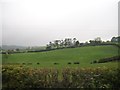
2
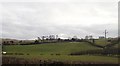
Drumlin land between the B8 (Newry Road) and Carmeen Road
This area is located between The Alt and Hilltown. The snowbanks are all that remain of the snows brought by "The Beast from the East" Mk1.
Image: © Eric Jones
Taken: 13 Mar 2018
0.25 miles