IMAGES TAKEN NEAR TO
Castlewellan Road, NEWRY, BT34 5EL
Introduction
This page details the photographs taken nearby to Castlewellan Road, BT34 5EL by members of the Geograph project.
The Geograph project started in 2005 with the aim of publishing, organising and preserving representative images for every square kilometre of Great Britain, Ireland and the Isle of Man.

There are currently over 7.5m images from over14,400 individuals and you can help contribute to the project by visiting https://www.geograph.org.uk
Image Map
Images are licensed for reuse under creativecommons.org/licenses/by-sa/2.0
Notes
- Clicking on the map will re-center to the selected point.
- The higher the marker number, the further away the image location is from the centre of the postcode.
Image Listing (29 Images Found)
Images are licensed for reuse under creativecommons.org/licenses/by-sa/2.0
Image
Details
Distance
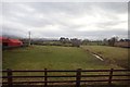
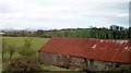
1
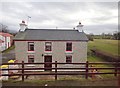
Farmhouse and outbuildings on the Castlewellan Road
Image: © Eric Jones
Taken: 13 Mar 2018
0.01 miles
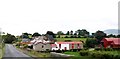
2
A hamlet on the A 25 (Castlewellan Road) in Moneygore TD
Image: © Eric Jones
Taken: 9 Apr 2018
0.01 miles
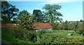
3
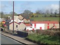
Traditional farm buildings in Moneygore TD
These stand on the south side of the A25 (Castlewellan Road).
Image: © Eric Jones
Taken: 9 Apr 2018
0.01 miles
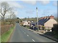
4
Settlement alongside the A25 between Sugar Bridge and McCombs Bridge
Image: © Eric Jones
Taken: 2 Sep 2014
0.02 miles
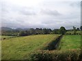
5
Pastureland with stream in Drumnascamph TD
This land and adjoining farm sheds lie south of the A25 (Castlewellan Road). The Mournes form the background.
Image: © Eric Jones
Taken: 13 Mar 2018
0.03 miles
6
Hedges and ditch at Sugar Bridge, Rathfriland
Image: © Eric Jones
Taken: 17 Jul 2010
0.04 miles
7
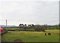
View South across grazing land from the A25
The circle of Scots Pines in the middle distance marks the site of the Cavan Rath.
Image]
Image: © Eric Jones
Taken: 5 Feb 2018
0.05 miles
8
Tin roofed field barn next to the A25 (Castlewellan Road)
Image: © Eric Jones
Taken: 25 Sep 2017
0.11 miles
9
Tin roofed farm building alongside the A25
Image: © Eric Jones
Taken: 30 Apr 2013
0.11 miles
10
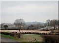
Farmland between the Bann and the town of Rathfriland
The water tower at Rathfriland is visible in the background.
Image: © Eric Jones
Taken: 11 Apr 2018
0.11 miles