IMAGES TAKEN NEAR TO
Glenhone Road, NEWRY, BT34 5DY
Introduction
This page details the photographs taken nearby to Glenhone Road, BT34 5DY by members of the Geograph project.
The Geograph project started in 2005 with the aim of publishing, organising and preserving representative images for every square kilometre of Great Britain, Ireland and the Isle of Man.

There are currently over 7.5m images from over14,400 individuals and you can help contribute to the project by visiting https://www.geograph.org.uk
Image Map
Images are licensed for reuse under creativecommons.org/licenses/by-sa/2.0
Notes
- Clicking on the map will re-center to the selected point.
- The higher the marker number, the further away the image location is from the centre of the postcode.
Image Listing (2 Images Found)
Images are licensed for reuse under creativecommons.org/licenses/by-sa/2.0
Image
Details
Distance
1
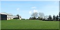
Farm sheds on rising ground between the A25 (Newry Road) and the Glenhorne Road
Image: © Eric Jones
Taken: 14 Mar 2017
0.12 miles
2
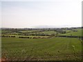
View across farmland to the Newry Road
This view is taken from the Ardaragh Road. The Mourne Mountains form a hazy background. The water tower at Rathfriland can be seen on the skyline on the extreme left.
Image: © Eric Jones
Taken: 24 Mar 2012
0.20 miles