IMAGES TAKEN NEAR TO
Gransha Road, NEWRY, BT34 5BU
Introduction
This page details the photographs taken nearby to Gransha Road, BT34 5BU by members of the Geograph project.
The Geograph project started in 2005 with the aim of publishing, organising and preserving representative images for every square kilometre of Great Britain, Ireland and the Isle of Man.

There are currently over 7.5m images from over14,400 individuals and you can help contribute to the project by visiting https://www.geograph.org.uk
Image Map
Images are licensed for reuse under creativecommons.org/licenses/by-sa/2.0
Notes
- Clicking on the map will re-center to the selected point.
- The higher the marker number, the further away the image location is from the centre of the postcode.
Image Listing (6 Images Found)
Images are licensed for reuse under creativecommons.org/licenses/by-sa/2.0
Image
Details
Distance
1
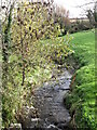
The Tullyquilly River
This stream is a tributary of a tributary of the Clanrye (or Newry) River.
Image: © Eric Jones
Taken: 27 Oct 2011
0.17 miles
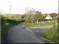
2
The Tullyquilly Bridge
This carries the Gransha Road across the Tullyquilly River.
Image: © Eric Jones
Taken: 27 Oct 2011
0.17 miles
3
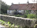
Derelict cottages at the Tullyquilly Bridge
Image: © Eric Jones
Taken: 27 Oct 2011
0.19 miles
4
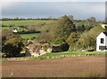
Ruined farmhouse at Tullyquilly
Part of the site is now occupied a new house.
Image: © Eric Jones
Taken: 27 Oct 2011
0.19 miles
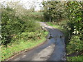
5
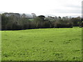
Pastureland south of the hamlet of Tullyquilly
Image: © Eric Jones
Taken: 27 Oct 2011
0.20 miles