IMAGES TAKEN NEAR TO
New Line, NEWRY, BT34 5BP
Introduction
This page details the photographs taken nearby to New Line, BT34 5BP by members of the Geograph project.
The Geograph project started in 2005 with the aim of publishing, organising and preserving representative images for every square kilometre of Great Britain, Ireland and the Isle of Man.

There are currently over 7.5m images from over14,400 individuals and you can help contribute to the project by visiting https://www.geograph.org.uk
Image Map
Images are licensed for reuse under creativecommons.org/licenses/by-sa/2.0
Notes
- Clicking on the map will re-center to the selected point.
- The higher the marker number, the further away the image location is from the centre of the postcode.
Image Listing (6 Images Found)
Images are licensed for reuse under creativecommons.org/licenses/by-sa/2.0
Image
Details
Distance
1
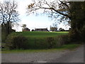
Farmhouse on a drumlin above the New Line Road
Image: © Eric Jones
Taken: 27 Oct 2011
0.10 miles
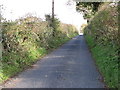
2
The New Line approaching the northern end of Drumgreenagh Road
The Drumgreenagh Road leads southwards to the A25.
Image: © Eric Jones
Taken: 27 Oct 2011
0.12 miles
3
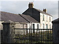
Disused farmhouse on Drumgreenagh Road
This is one of scores of such farmhouses in Co Down, and has resulted from farm amalgamations.
Image: © Eric Jones
Taken: 27 Oct 2011
0.12 miles
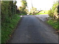
4
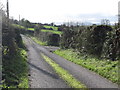
The New Line approaching the junction with Drumgreenagh Road
This is a lightly used country road.
Image: © Eric Jones
Taken: 27 Oct 2011
0.16 miles
6
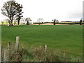
Farmland north-west of the New Line
The landscape is that created by glacial deposition.
Image: © Eric Jones
Taken: 27 Oct 2011
0.25 miles