IMAGES TAKEN NEAR TO
Old Newry Road, NEWRY, BT34 5BG
Introduction
This page details the photographs taken nearby to Old Newry Road, BT34 5BG by members of the Geograph project.
The Geograph project started in 2005 with the aim of publishing, organising and preserving representative images for every square kilometre of Great Britain, Ireland and the Isle of Man.

There are currently over 7.5m images from over14,400 individuals and you can help contribute to the project by visiting https://www.geograph.org.uk
Image Map
Images are licensed for reuse under creativecommons.org/licenses/by-sa/2.0
Notes
- Clicking on the map will re-center to the selected point.
- The higher the marker number, the further away the image location is from the centre of the postcode.
Image Listing (12 Images Found)
Images are licensed for reuse under creativecommons.org/licenses/by-sa/2.0
Image
Details
Distance
3
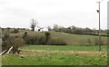
Bends in the road west of Croan Bridge
The section of the Old Newry Road west of Croan Bridge is known as Glenvale Road
Image: © Eric Jones
Taken: 14 Feb 2012
0.12 miles
4
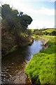
The Clanrye Valley from the Glenvale Road
Image: © Eric Jones
Taken: 14 Feb 2012
0.16 miles
6
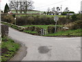
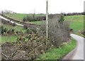
The northern end of Crossan Road at Croan Bridge
This road runs southwards in the direction of Mayobridge.
Image: © Eric Jones
Taken: 14 Feb 2012
0.19 miles
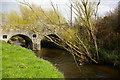
7

Croan Bridge
This bridge spans the Clanrye River.
Image: © Eric Jones
Taken: 14 Feb 2012
0.19 miles
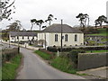
10
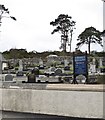
The grave yard at Ryans Presbyterian Church
Image: © Eric Jones
Taken: 14 Feb 2012
0.21 miles