IMAGES TAKEN NEAR TO
Slievenagarragh, NEWRY, BT34 5BF
Introduction
This page details the photographs taken nearby to Slievenagarragh, BT34 5BF by members of the Geograph project.
The Geograph project started in 2005 with the aim of publishing, organising and preserving representative images for every square kilometre of Great Britain, Ireland and the Isle of Man.

There are currently over 7.5m images from over14,400 individuals and you can help contribute to the project by visiting https://www.geograph.org.uk
Image Map
Images are licensed for reuse under creativecommons.org/licenses/by-sa/2.0
Notes
- Clicking on the map will re-center to the selected point.
- The higher the marker number, the further away the image location is from the centre of the postcode.
Image Listing (36 Images Found)
Images are licensed for reuse under creativecommons.org/licenses/by-sa/2.0
Image
Details
Distance
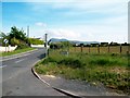
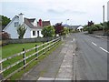
1
The Yellow Road at Hilltown
The Mourne Mountains can be seen in the background.
Image: © Eric Jones
Taken: 14 Sep 2010
0.14 miles
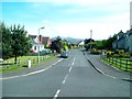
2
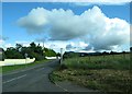
The Hilltown end of Yellow Road
The Yellow Road runs south into hilly country.
Image: © Eric Jones
Taken: 24 Jun 2016
0.16 miles
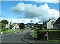
3
The northern end of Yellow Road at Hilltown
Image: © Eric Jones
Taken: 20 Jun 2012
0.16 miles
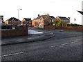
4
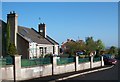
Oakridge Villas
Modern housing off Newry Road, Hilltown.
Image: © Oliver Dixon
Taken: 12 May 2007
0.17 miles
5
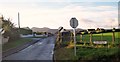
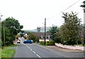
![The mouth of Yellow Road from the B8 [Newry Road]](https://s2.geograph.org.uk/geophotos/01/75/01/1750130_9398ada3_120x120.jpg)
The mouth of Yellow Road from the B8 [Newry Road]
Image: © Eric Jones
Taken: 20 Feb 2010
0.17 miles
7
Oakridge Villas
This cul-de-sac is located on the western outskirts of Hilltown.
Image: © Eric Jones
Taken: 24 Jun 2016
0.18 miles
8
The Ferns Estate off Rostrevor Road, Hilltown
Image: © Eric Jones
Taken: 11 Dec 2012
0.19 miles
9
Entering Hilltown from the west along the B8
Image: © Eric Jones
Taken: 2 Sep 2014
0.20 miles