IMAGES TAKEN NEAR TO
Greenhill Road, NEWRY, BT34 5AS
Introduction
This page details the photographs taken nearby to Greenhill Road, BT34 5AS by members of the Geograph project.
The Geograph project started in 2005 with the aim of publishing, organising and preserving representative images for every square kilometre of Great Britain, Ireland and the Isle of Man.

There are currently over 7.5m images from over14,400 individuals and you can help contribute to the project by visiting https://www.geograph.org.uk
Image Map
Images are licensed for reuse under creativecommons.org/licenses/by-sa/2.0
Notes
- Clicking on the map will re-center to the selected point.
- The higher the marker number, the further away the image location is from the centre of the postcode.
Image Listing (11 Images Found)
Images are licensed for reuse under creativecommons.org/licenses/by-sa/2.0
Image
Details
Distance
1
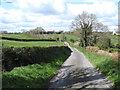
The descending Greenhill Road
There is a sharp bend in the middle of the descent.
Image: © Eric Jones
Taken: 14 Apr 2012
0.06 miles
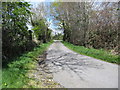
2
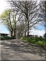
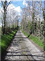
Private tree-lined avenue leading west from Greenhill Road
Image: © Eric Jones
Taken: 14 Apr 2012
0.07 miles
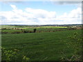
3
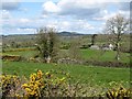
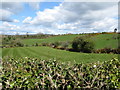
View northwards across farmland from the Greenhill Road
The whin capped Knockiveagh Hill dominates the skyline.
Image: © Eric Jones
Taken: 14 Apr 2012
0.12 miles
4
The valley of a tributary of the upper Clanrye river
Image: © Eric Jones
Taken: 14 Apr 2012
0.13 miles
5
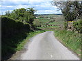
View west-northwest along Greenhill Road
Image: © Eric Jones
Taken: 14 Apr 2012
0.15 miles
6
Greenhill Road ascending from a minor valley towards a 90 degree bend
Image: © Eric Jones
Taken: 14 Apr 2012
0.19 miles
7
View south-westwards from the bend across farmland
Image: © Eric Jones
Taken: 14 Apr 2012
0.23 miles
8
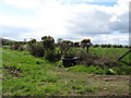
Drumlin topography west of Macfadden's Hillhead
The area shown is good farming land with the emphasis being on pastoral farming. Much of the area is in cultivated grass.
Image: © Eric Jones
Taken: 14 Apr 2012
0.23 miles
9
Greenhill Road immediately north of the 90 degree bend
Having crossed the valley the road changes direction from west to north.
Image: © Eric Jones
Taken: 14 Apr 2012
0.23 miles