IMAGES TAKEN NEAR TO
Newry Road, NEWRY, BT34 5AL
Introduction
This page details the photographs taken nearby to Newry Road, BT34 5AL by members of the Geograph project.
The Geograph project started in 2005 with the aim of publishing, organising and preserving representative images for every square kilometre of Great Britain, Ireland and the Isle of Man.

There are currently over 7.5m images from over14,400 individuals and you can help contribute to the project by visiting https://www.geograph.org.uk
Image Map
Images are licensed for reuse under creativecommons.org/licenses/by-sa/2.0
Notes
- Clicking on the map will re-center to the selected point.
- The higher the marker number, the further away the image location is from the centre of the postcode.
Image Listing (6 Images Found)
Images are licensed for reuse under creativecommons.org/licenses/by-sa/2.0
Image
Details
Distance
1
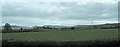
Grazing land on the western outskirts of Rathfriland
The Western Mournes form the background.
Image: © Eric Jones
Taken: 3 Apr 2017
0.10 miles
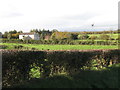
2
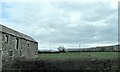
Farm outbuildings on the A25 between Barnmeen and Rathfriland
Image: © Eric Jones
Taken: 4 Apr 2017
0.12 miles
3
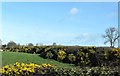
Whin hedges on the north side of the A25
Image: © Eric Jones
Taken: 14 Mar 2017
0.17 miles
4
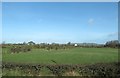
Farmland on the north side of the A25
These fields are situated on the western fringe of Rathfriland. The hill in the background is Knockiveagh which is in the heart of the Bronte Country.
Image: © Eric Jones
Taken: 14 Mar 2017
0.17 miles
5
Farmhouse with wind generator south of Redbridge Road
Image: © Eric Jones
Taken: 27 Oct 2011
0.22 miles
6
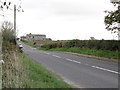
The Newry Road east of the Grocer's Road junction
Image: © Eric Jones
Taken: 27 Oct 2011
0.25 miles