IMAGES TAKEN NEAR TO
Upper Ballinran Road, NEWRY, BT34 4ZU
Introduction
This page details the photographs taken nearby to Upper Ballinran Road, BT34 4ZU by members of the Geograph project.
The Geograph project started in 2005 with the aim of publishing, organising and preserving representative images for every square kilometre of Great Britain, Ireland and the Isle of Man.

There are currently over 7.5m images from over14,400 individuals and you can help contribute to the project by visiting https://www.geograph.org.uk
Image Map
Images are licensed for reuse under creativecommons.org/licenses/by-sa/2.0
Notes
- Clicking on the map will re-center to the selected point.
- The higher the marker number, the further away the image location is from the centre of the postcode.
Image Listing (19 Images Found)
Images are licensed for reuse under creativecommons.org/licenses/by-sa/2.0
Image
Details
Distance
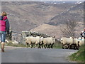
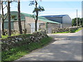
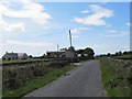
1
Farm house and buildings on a minor road linking Leitrim and Ballinran Roads
Image: © Eric Jones
Taken: 19 Mar 2011
0.02 miles
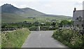
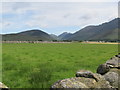
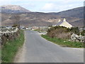
2
View north-eastwards towards Ballinran Road
The familiar profile of Slieve Binnian forms the background.
Image: © Eric Jones
Taken: 15 Jul 2012
0.03 miles
3
Farm buildings on the lane linking Ballinran and Leitrim roads
Image: © Eric Jones
Taken: 15 Jul 2012
0.03 miles
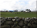
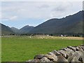
4
View across farmland towards the Silent Valley
Image: © Eric Jones
Taken: 15 Jul 2012
0.06 miles
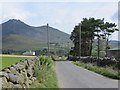
6
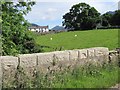
Farmhouse between Leiter and Ballinran Roads
Silent Valley can be seen in the distance.
Image: © Eric Jones
Taken: 15 Jul 2012
0.11 miles
7
Settlement along the upper section of Ballinran Road
Image: © Eric Jones
Taken: 19 Mar 2011
0.12 miles
8
Farm house and buildings on Ballinran Road
Image: © Eric Jones
Taken: 15 Jul 2012
0.14 miles