IMAGES TAKEN NEAR TO
Longstone Road, NEWRY, BT34 4UZ
Introduction
This page details the photographs taken nearby to Longstone Road, BT34 4UZ by members of the Geograph project.
The Geograph project started in 2005 with the aim of publishing, organising and preserving representative images for every square kilometre of Great Britain, Ireland and the Isle of Man.

There are currently over 7.5m images from over14,400 individuals and you can help contribute to the project by visiting https://www.geograph.org.uk
Image Map
Images are licensed for reuse under creativecommons.org/licenses/by-sa/2.0
Notes
- Clicking on the map will re-center to the selected point.
- The higher the marker number, the further away the image location is from the centre of the postcode.
Image Listing (3 Images Found)
Images are licensed for reuse under creativecommons.org/licenses/by-sa/2.0
Image
Details
Distance
1
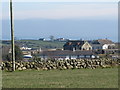
The Moneydarragh Primary School
The school is the long building in the foreground. There has been a school on this site since 1827 and the present building dates to the 1890s. This is a Catholic ethos school and serves the wider Longstone area. This school was closed in June 2018.
http://www.moneydarraghps.org/index.htm
https://www.bbc.co.uk/news/uk-northern-ireland-44621623
Image: © Eric Jones
Taken: 16 Mar 2011
0.06 miles
3
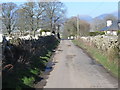
View north along Sabbath Hill
The southern flank of the Mournes can be seen in the background.
Image: © Eric Jones
Taken: 16 Mar 2011
0.24 miles