IMAGES TAKEN NEAR TO
Stewarts Road, NEWRY, BT34 4UE
Introduction
This page details the photographs taken nearby to Stewarts Road, BT34 4UE by members of the Geograph project.
The Geograph project started in 2005 with the aim of publishing, organising and preserving representative images for every square kilometre of Great Britain, Ireland and the Isle of Man.

There are currently over 7.5m images from over14,400 individuals and you can help contribute to the project by visiting https://www.geograph.org.uk
Image Map
Images are licensed for reuse under creativecommons.org/licenses/by-sa/2.0
Notes
- Clicking on the map will re-center to the selected point.
- The higher the marker number, the further away the image location is from the centre of the postcode.
Image Listing (1 Images Found)
Images are licensed for reuse under creativecommons.org/licenses/by-sa/2.0
Image
Details
Distance
1
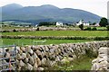
View towards Slieve Donard
The view from the bend in the road above St. Pious Hill. The ridge below Slieve Donard, including The Long Mountain and Spences Mountain, can be seen.
Image: © Simon Mortimer
Taken: 8 Jul 2009
0.22 miles