IMAGES TAKEN NEAR TO
Kilkeel Road, NEWRY, BT34 4TW
Introduction
This page details the photographs taken nearby to Kilkeel Road, BT34 4TW by members of the Geograph project.
The Geograph project started in 2005 with the aim of publishing, organising and preserving representative images for every square kilometre of Great Britain, Ireland and the Isle of Man.

There are currently over 7.5m images from over14,400 individuals and you can help contribute to the project by visiting https://www.geograph.org.uk
Image Map
Images are licensed for reuse under creativecommons.org/licenses/by-sa/2.0
Notes
- Clicking on the map will re-center to the selected point.
- The higher the marker number, the further away the image location is from the centre of the postcode.
Image Listing (18 Images Found)
Images are licensed for reuse under creativecommons.org/licenses/by-sa/2.0
Image
Details
Distance
1
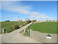
Access road to Four Winds Farm, Annalong
Image: © Eric Jones
Taken: 19 Mar 2011
0.04 miles
2
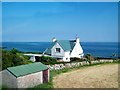
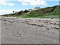
House above the sea at Danes' Bridge on the A2 (Annalong Road)
Image: © Eric Jones
Taken: 1 Jul 2014
0.07 miles
3
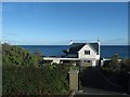
House facing the sea between Ballymartin and Annalong
Image: © Eric Jones
Taken: 22 Sep 2015
0.08 miles
4
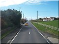
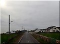
A straight section of the A2 (Kilkeel Road)
Image: © Eric Jones
Taken: 2 May 2016
0.08 miles
5
Houses on the cliff top above Danes' Bridge Point
Image: © Eric Jones
Taken: 23 Apr 2011
0.09 miles
6

View south westwards along the A2 (Annalong Road)
This is an area of linear rural settlement.
Image: © Eric Jones
Taken: 12 Jul 2012
0.09 miles
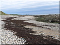
9
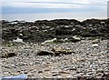
Danes' Bridge Point between Ballymartin and Annalong
Image: © Eric Jones
Taken: 23 Apr 2011
0.13 miles
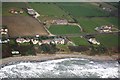
10
Ribbon development along the A2 between Annalong and Ballymartin
Image: © Eric Jones
Taken: 16 Feb 2018
0.15 miles