IMAGES TAKEN NEAR TO
Tullyframe Road, NEWRY, BT34 4RY
Introduction
This page details the photographs taken nearby to Tullyframe Road, BT34 4RY by members of the Geograph project.
The Geograph project started in 2005 with the aim of publishing, organising and preserving representative images for every square kilometre of Great Britain, Ireland and the Isle of Man.

There are currently over 7.5m images from over14,400 individuals and you can help contribute to the project by visiting https://www.geograph.org.uk
Image Map
Images are licensed for reuse under creativecommons.org/licenses/by-sa/2.0
Notes
- Clicking on the map will re-center to the selected point.
- The higher the marker number, the further away the image location is from the centre of the postcode.
Image Listing (13 Images Found)
Images are licensed for reuse under creativecommons.org/licenses/by-sa/2.0
Image
Details
Distance
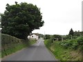
1
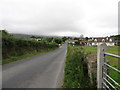
Linear settlement along Tullyframe Roads
The camera is pointing northwards.
Image: © Eric Jones
Taken: 23 Aug 2015
0.01 miles
2
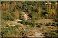
Old quarry near Kilkeel
This disused sand quarry is beside the Tullyframe Road near Kilkeel.
Image: © Albert Bridge
Taken: 13 Oct 2007
0.04 miles
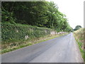
3
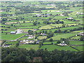
Houses on Tullyframe Road viewed from Knockchree Mountain
Image: © Eric Jones
Taken: 29 Aug 2015
0.10 miles
4
11kV power lines in the Tullyframe Road area
Image: © Eric Jones
Taken: 23 Aug 2015
0.12 miles
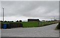
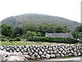
5
Traditional farm buildings and dry stone wall alongside Tullyframe Road
Image: © Eric Jones
Taken: 23 Aug 2015
0.13 miles
6
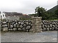
Ulster single stone wall in the shadow of Knockshee
Northern Ireland has some 8,000 kms of dry stone field walls. The most complete pattern of stone walls is found in the Kingdom of Mourne. Here the stone cleared off fields - mainly granite - are rounded and the finished walls are characterised by holes between the stones. The walls tend to be about 1.5m high and 1m wide at the base, tapering to 0.25m at the top.
Image: © Eric Jones
Taken: 23 Aug 2015
0.14 miles
7
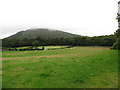
The walls of Mourne Park estate viewed from Tullyframe Road
The hill in the background, on the other side of the Whitewater River, is Knockchree.
Image: © Eric Jones
Taken: 23 Aug 2015
0.14 miles
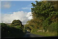
10
The Mourne Park House demesne outer wall
The camera is pointing southwards along Tullyframe Road.
Image: © Eric Jones
Taken: 23 Aug 2015
0.18 miles