IMAGES TAKEN NEAR TO
Irvington Close, NEWRY, BT34 4QQ
Introduction
This page details the photographs taken nearby to Irvington Close, BT34 4QQ by members of the Geograph project.
The Geograph project started in 2005 with the aim of publishing, organising and preserving representative images for every square kilometre of Great Britain, Ireland and the Isle of Man.

There are currently over 7.5m images from over14,400 individuals and you can help contribute to the project by visiting https://www.geograph.org.uk
Image Map
Images are licensed for reuse under creativecommons.org/licenses/by-sa/2.0
Notes
- Clicking on the map will re-center to the selected point.
- The higher the marker number, the further away the image location is from the centre of the postcode.
Image Listing (146 Images Found)
Images are licensed for reuse under creativecommons.org/licenses/by-sa/2.0
Image
Details
Distance
1
View northwards along Knockchree Avenue, Kilkeel
The Mourne Mountains form the background.
Image: © Eric Jones
Taken: 2 Apr 2011
0.06 miles
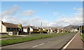
2
Melrose Park off Manse Road
This is a fairly new estate of houses and bungalows.
Image: © Eric Jones
Taken: 25 May 2010
0.09 miles
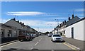
3
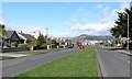
The broad Knockchree Avenue
This is one of the pleasant streets in Co Down.
Image: © Eric Jones
Taken: 2 Apr 2011
0.10 miles
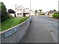
4
Manse Road near the junction with Irvington Avenue
The Rectory stands on the opposite side of the road.
Image: © Eric Jones
Taken: 25 May 2010
0.11 miles
5
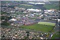
Kilkeel High School
This isn't a brilliant photo, taken from the air on a dull day, but as no-one else has submitted anything for the square...
Image: © David Crozier
Taken: 29 Dec 2008
0.13 miles
6
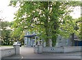
The Rectory, Manse Road, Chill Chaoil/Kilkeel
This is the residence of the Rector of Christ Church (CofI) which is situated in Newry Street.
Image: © Eric Jones
Taken: 25 May 2010
0.13 miles
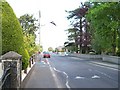
7
Harbour Drive, Kilkeel
This street links Harbour Road and Knockchree Avenue.
Image: © Eric Jones
Taken: 12 Jul 2012
0.13 miles
9

Loyal Sons of Ulster Glenloughan (LOL 1914) entering the Mourne District Park
This is the end of the long outward march and time for a picnic and for listening to speeches before marching back home again.
http://www.paradescommission.org/parades/?parade=38894
Image: © Eric Jones
Taken: 12 Jul 2012
0.15 miles
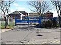
10
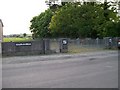
LOL No 6's Mourne District Park
This is the parading ground of Loyal Orange Lodge No 6, and where marches have traditionally begun and ended. A reviewing stand can be seen at the end of the line of trees and symbols of the Orange Order decorate the gate posts.
Image: © Eric Jones
Taken: 25 May 2010
0.15 miles