IMAGES TAKEN NEAR TO
Brackenagh West Road, NEWRY, BT34 4PP
Introduction
This page details the photographs taken nearby to Brackenagh West Road, BT34 4PP by members of the Geograph project.
The Geograph project started in 2005 with the aim of publishing, organising and preserving representative images for every square kilometre of Great Britain, Ireland and the Isle of Man.

There are currently over 7.5m images from over14,400 individuals and you can help contribute to the project by visiting https://www.geograph.org.uk
Image Map
Images are licensed for reuse under creativecommons.org/licenses/by-sa/2.0
Notes
- Clicking on the map will re-center to the selected point.
- The higher the marker number, the further away the image location is from the centre of the postcode.
Image Listing (18 Images Found)
Images are licensed for reuse under creativecommons.org/licenses/by-sa/2.0
Image
Details
Distance
1

Blocked off field access lane in the townland of Brackenagh West
Image: © Eric Jones
Taken: 15 May 2011
0.05 miles


4

Cultivated grass on the east sidee of Brackeneagh West Road
Image: © Eric Jones
Taken: 15 May 2011
0.12 miles
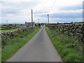
5
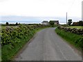
Brackenagh Road West north of Dun Mhaire Gaeiligh
The Irish Sea can be seen in the background
Image: © Eric Jones
Taken: 15 May 2011
0.14 miles
6
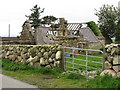
Ruined farmstead on Brackenagh Road West
Image: © Eric Jones
Taken: 15 May 2011
0.15 miles
7
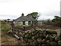
Disused cottage at Brackenagh West
The site appears to be in the process of redevelopment.
Image: © Eric Jones
Taken: 15 May 2011
0.15 miles
8
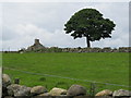
A ruined cottage and a magnificent tree on the west side of Brackenagh East Road
Image: © Eric Jones
Taken: 15 Jul 2012
0.16 miles
9

Field on the east side of Brackenagh West Road
Image: © Eric Jones
Taken: 15 May 2011
0.16 miles
10
View in the direction of the Irish Sea along Brackenagh East Road
Image: © Eric Jones
Taken: 15 Jul 2012
0.18 miles