IMAGES TAKEN NEAR TO
Nicholsons Road, NEWRY, BT34 4JN
Introduction
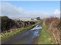
This page details the photographs taken nearby to Nicholsons Road, BT34 4JN by members of the Geograph project.
The Geograph project started in 2005 with the aim of publishing, organising and preserving representative images for every square kilometre of Great Britain, Ireland and the Isle of Man.

There are currently over 7.5m images from over14,400 individuals and you can help contribute to the project by visiting https://www.geograph.org.uk
Image Map
Images are licensed for reuse under creativecommons.org/licenses/by-sa/2.0
Notes
- Clicking on the map will re-center to the selected point.
- The higher the marker number, the further away the image location is from the centre of the postcode.
Image Listing (2 Images Found)
Images are licensed for reuse under creativecommons.org/licenses/by-sa/2.0
Image
Details
Distance
2
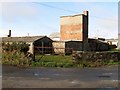
World War II structures on Nicholsons Road
These structures were part of a dispersed communal site belonging to nearby RAF Greencastle. The airfield completed in 1942 as a pilot training base was transferred to the Americans in 1943 when it became known as USAAF 237. The airfield was shut in 1945. Nicholsons Road is a minor road connecting the coast with the major Greencastle Road.
Image: © Eric Jones
Taken: 19 Feb 2011
0.13 miles