IMAGES TAKEN NEAR TO
Ballymageogh Road, NEWRY, BT34 4HW
Introduction
This page details the photographs taken nearby to Ballymageogh Road, BT34 4HW by members of the Geograph project.
The Geograph project started in 2005 with the aim of publishing, organising and preserving representative images for every square kilometre of Great Britain, Ireland and the Isle of Man.

There are currently over 7.5m images from over14,400 individuals and you can help contribute to the project by visiting https://www.geograph.org.uk
Image Map
Images are licensed for reuse under creativecommons.org/licenses/by-sa/2.0
Notes
- Clicking on the map will re-center to the selected point.
- The higher the marker number, the further away the image location is from the centre of the postcode.
Image Listing (4 Images Found)
Images are licensed for reuse under creativecommons.org/licenses/by-sa/2.0
Image
Details
Distance
1
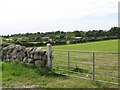
Shelter-belt woodland on the eastern edge of the parkland of Mourne Park House
The grounds of this mansion have now been converted to form the course of the Kilkeel Golf Club.
Image: © Eric Jones
Taken: 15 Jun 2011
0.08 miles
2
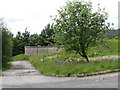
Covered Reservoir on the Ballymageogh Road
Image: © Eric Jones
Taken: 15 Jun 2011
0.08 miles
3
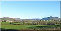
The Mourne Plain enclosed by the Mourne Mountain
This early morning image was taken from the Newry Road, west of Kilkeel. The iconic Slieve Binnian on the left is visible from all parts of the plain.
Image: © Eric Jones
Taken: 23 Nov 2016
0.16 miles
4
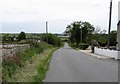
View south in the direction of the sea along Ballymageogh Road
Image: © Eric Jones
Taken: 15 Jun 2011
0.20 miles