IMAGES TAKEN NEAR TO
Moyad Road, NEWRY, BT34 4HJ
Introduction
This page details the photographs taken nearby to Moyad Road, BT34 4HJ by members of the Geograph project.
The Geograph project started in 2005 with the aim of publishing, organising and preserving representative images for every square kilometre of Great Britain, Ireland and the Isle of Man.

There are currently over 7.5m images from over14,400 individuals and you can help contribute to the project by visiting https://www.geograph.org.uk
Image Map
Images are licensed for reuse under creativecommons.org/licenses/by-sa/2.0
Notes
- Clicking on the map will re-center to the selected point.
- The higher the marker number, the further away the image location is from the centre of the postcode.
Image Listing (3 Images Found)
Images are licensed for reuse under creativecommons.org/licenses/by-sa/2.0
Image
Details
Distance
1
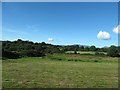
Partially reclaimed bog land south of the Dougans Road junction
Image: © Eric Jones
Taken: 13 Sep 2015
0.06 miles
2
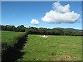
Improved grazing land and woodland on the west side of the B27
The hill in the background is KnockchreeImage
Image: © Eric Jones
Taken: 13 Sep 2015
0.10 miles
3
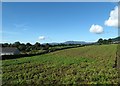
Potato field on the west side of the B27
Image: © Eric Jones
Taken: 13 Sep 2015
0.13 miles