IMAGES TAKEN NEAR TO
Lisnavale, NEWRY, BT34 4FS
Introduction
This page details the photographs taken nearby to Lisnavale, BT34 4FS by members of the Geograph project.
The Geograph project started in 2005 with the aim of publishing, organising and preserving representative images for every square kilometre of Great Britain, Ireland and the Isle of Man.

There are currently over 7.5m images from over14,400 individuals and you can help contribute to the project by visiting https://www.geograph.org.uk
Image Map
Images are licensed for reuse under creativecommons.org/licenses/by-sa/2.0
Notes
- Clicking on the map will re-center to the selected point.
- The higher the marker number, the further away the image location is from the centre of the postcode.
Image Listing (19 Images Found)
Images are licensed for reuse under creativecommons.org/licenses/by-sa/2.0
Image
Details
Distance
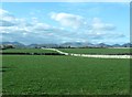
1
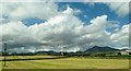
Farmland on the north-eastern fringe of Kilkeel
The horned mountain (background, right) is Slieve Binnian.
Image: © Eric Jones
Taken: 28 May 2015
0.08 miles
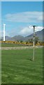
2
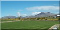
Grass crop and wind turbine on the north side of Newcastle Road, Kilkeel
The Mournes form the background.
Image: © Eric Jones
Taken: 2 May 2016
0.09 miles
3
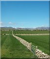
Stone wall enclosed fields north of Newcastle Road
Image: © Eric Jones
Taken: 2 May 2016
0.10 miles
4
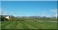
Flowery meadow on the north side of Newcastle Road, Kilkeel
Image: © Eric Jones
Taken: 2 May 2016
0.10 miles
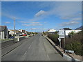
6
Entering Kilkeel along the A2 (Newcastle Road)
Image: © Eric Jones
Taken: 16 Feb 2018
0.13 miles
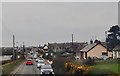
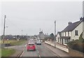
7
View west along Newcastle Road, Kilkeel
The cube shaped building on the extreme right is the Mourne Stimulus Day Centre, a non-profit voluntary organisation formed in 1995. The white van in the middle ground is exiting Council Road.
Image: © Eric Jones
Taken: 16 Feb 2018
0.13 miles
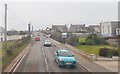
8
Farmland on the north side of the A2 (Newcastle Road) at Kilkeel
Image: © Eric Jones
Taken: 18 Mar 2011
0.14 miles
10
Leestone Road junction on the Newcastle Road
Leestone Road, a cul de sac runs down to the coast a mile away.
Image: © Eric Jones
Taken: 16 Feb 2018
0.16 miles