IMAGES TAKEN NEAR TO
The Cove, NEWRY, BT34 4BJ
Introduction
This page details the photographs taken nearby to The Cove, BT34 4BJ by members of the Geograph project.
The Geograph project started in 2005 with the aim of publishing, organising and preserving representative images for every square kilometre of Great Britain, Ireland and the Isle of Man.

There are currently over 7.5m images from over14,400 individuals and you can help contribute to the project by visiting https://www.geograph.org.uk
Image Map
Images are licensed for reuse under creativecommons.org/licenses/by-sa/2.0
Notes
- Clicking on the map will re-center to the selected point.
- The higher the marker number, the further away the image location is from the centre of the postcode.
Image Listing (117 Images Found)
Images are licensed for reuse under creativecommons.org/licenses/by-sa/2.0
Image
Details
Distance
1
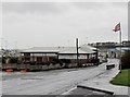
Kilkeel Primary School
This shares a campus with the Kilkeel High School.
Image: © Eric Jones
Taken: 25 May 2010
0.06 miles
2
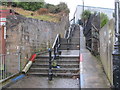
Steps linking Rooney Road with Harbour Road
Image: © Eric Jones
Taken: 5 Feb 2011
0.10 miles
3
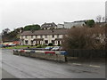
Willow Cove Estate off Rooney Road
This terrace of houses is situated opposite the Nautilus Centre.
Image: © Eric Jones
Taken: 5 Feb 2011
0.11 miles
4

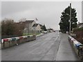
View northwestwards along Harbour Road
This road links the harbour with the town centre.
Image: © Eric Jones
Taken: 12 Jul 2012
0.11 miles
5
View north across the Rooney Road bridge
Rooney Road is located in the predominantly Loyalist Central Ward of Kilkeel.
Image: © Eric Jones
Taken: 5 Feb 2011
0.11 miles
6
Approaching the Nautilus Centre along Rooney Road
The Nautilus Centre houses the Mourne Maritime Visitor Centre, Kilkeel's Tourist Information Centre, restaurants and a gospel hall.
http://www.discovernorthernireland.com/Nautilus-Centre-and-Mourne-Maritime-Visitor-Centre-Kilkeel-Newry-P1850
Image: © Eric Jones
Taken: 5 Feb 2011
0.13 miles
7
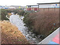
The Little Kilkeel River downstream of the Rooney Road bridge
The banks of the river have been concreted to reduce the effects of erosion.The river flows into Kilkeel Harbour. The building on the eastern side of the river is the Nautilus Centre.
Image: © Eric Jones
Taken: 5 Feb 2011
0.13 miles
8

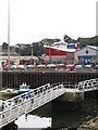
The Nautilus Centre, Kilkeel Harbour
This houses a museum and a tourist information centre as well as a number of shops and businesses,
Image: © Eric Jones
Taken: 12 Jul 2012
0.13 miles
9
The Steadfast nears completion
Work has been under way on the "Steadfast" since 2000.
The earliest image of "Steadfast" submitted on Geograph was taken by Albert Bridge in 2007. Image
The ship was transferred to the waters of Kilkeel Harbour in 2014.
http://www.belfasttelegraph.co.uk/news/local-national/northern-ireland/we-have-liftoff14-years-in-making-fishing-boat-built-by-brothers-finally-takes-to-the-water-30775531.html
Image: © Eric Jones
Taken: 8 Aug 2012
0.14 miles
10
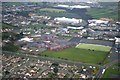
Kilkeel High School
This isn't a brilliant photo, taken from the air on a dull day, but as no-one else has submitted anything for the square...
Image: © David Crozier
Taken: 29 Dec 2008
0.14 miles