IMAGES TAKEN NEAR TO
Cedar Heights, NEWRY, BT34 4BA
Introduction
This page details the photographs taken nearby to Cedar Heights, BT34 4BA by members of the Geograph project.
The Geograph project started in 2005 with the aim of publishing, organising and preserving representative images for every square kilometre of Great Britain, Ireland and the Isle of Man.

There are currently over 7.5m images from over14,400 individuals and you can help contribute to the project by visiting https://www.geograph.org.uk
Image Map
Images are licensed for reuse under creativecommons.org/licenses/by-sa/2.0
Notes
- Clicking on the map will re-center to the selected point.
- The higher the marker number, the further away the image location is from the centre of the postcode.
Image Listing (48 Images Found)
Images are licensed for reuse under creativecommons.org/licenses/by-sa/2.0
Image
Details
Distance
1

The Aughrim River Bridge on Mountain Road
Image: © Eric Jones
Taken: 20 Feb 2011
0.02 miles

3
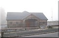
The Mountain Road Gospel Hall, Kilkeel
Gospel Halls are an ubiquitous feature of Northern Ireland's religious scene.
Image: © Eric Jones
Taken: 20 Feb 2011
0.03 miles
4
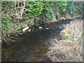
Bend in the Aughrim River below the Mountain Road Bridge
Image: © Eric Jones
Taken: 20 Feb 2011
0.04 miles
5
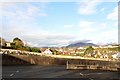
Houses on Mountain Road viewed from Newry Road
Image: © Eric Jones
Taken: 11 May 2010
0.05 miles
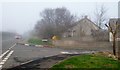
6
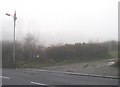
Farm lane off the Loyalist Mountain Road, Kilkeel
The mist had crept in from the sea during the afternoon.
Image: © Eric Jones
Taken: 20 Feb 2011
0.06 miles
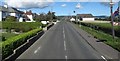
7
Houses on Mountain Road, Kilkeel
The Mournes form the background.
Image: © Eric Jones
Taken: 10 Nov 2012
0.07 miles
8
Entrance to Cromlech Park from Mountain Road
The name of this estate comes from the proximity of a Neolithic dolmen which is situated in a field behind the estate.
Image: © Eric Jones
Taken: 20 Feb 2011
0.08 miles
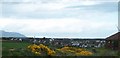
10
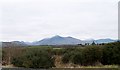
View across the valley of the Kilkeel River towards the Mourne Mountains
Binnian stands foremost at the centre of the image,
Image: © Eric Jones
Taken: 30 Jan 2011
0.15 miles