IMAGES TAKEN NEAR TO
Wood View Lane, NEWRY, BT34 3XN
Introduction
This page details the photographs taken nearby to Wood View Lane, BT34 3XN by members of the Geograph project.
The Geograph project started in 2005 with the aim of publishing, organising and preserving representative images for every square kilometre of Great Britain, Ireland and the Isle of Man.

There are currently over 7.5m images from over14,400 individuals and you can help contribute to the project by visiting https://www.geograph.org.uk
Image Map
Images are licensed for reuse under creativecommons.org/licenses/by-sa/2.0
Notes
- Clicking on the map will re-center to the selected point.
- The higher the marker number, the further away the image location is from the centre of the postcode.
Image Listing (7 Images Found)
Images are licensed for reuse under creativecommons.org/licenses/by-sa/2.0
Image
Details
Distance

2
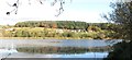
Settlement overlooking the Mill Dam Reservoir
These stand along the Upper Burren Road.
Image: © Eric Jones
Taken: 7 Nov 2016
0.19 miles
3
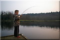
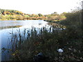
Mill Dam
The Mill Dam was originally built to power a flax (I believe) mill, on the Hall estate. It is now a trout fishery, with angling rights belonging to the Warrenpoint, Burren & Rostrevor Angling Club.
Image: © David Crozier
Taken: 27 Mar 2007
0.19 miles
4
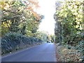
Greenan Road at Milltown
The woodland plantation on the left is within the Narrow Water Demesne.
Image: © Eric Jones
Taken: 7 Nov 2016
0.23 miles
5
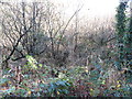
Wooded bog at the southern end of the Mill Dam Reservoir
The image was taken from the Greennan Road.
Image: © Eric Jones
Taken: 7 Nov 2016
0.24 miles
6
View east towards the retaining wall of the Mill Dam Reservoir
Image: © Eric Jones
Taken: 7 Nov 2016
0.25 miles
7
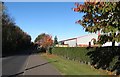
Units on the Milltown Industrial Estate, Greenan Road
This out of town estate has a number of manufacturing and retail units.
Image: © Eric Jones
Taken: 7 Nov 2016
0.25 miles