IMAGES TAKEN NEAR TO
Donaghaguy Close, NEWRY, BT34 3TT
Introduction
This page details the photographs taken nearby to Donaghaguy Close, BT34 3TT by members of the Geograph project.
The Geograph project started in 2005 with the aim of publishing, organising and preserving representative images for every square kilometre of Great Britain, Ireland and the Isle of Man.

There are currently over 7.5m images from over14,400 individuals and you can help contribute to the project by visiting https://www.geograph.org.uk
Image Map
Images are licensed for reuse under creativecommons.org/licenses/by-sa/2.0
Notes
- Clicking on the map will re-center to the selected point.
- The higher the marker number, the further away the image location is from the centre of the postcode.
Image Listing (7 Images Found)
Images are licensed for reuse under creativecommons.org/licenses/by-sa/2.0
Image
Details
Distance
1
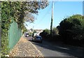
Entering The Burren from the south along the B7
The image was taken from the cross roads.
Image: © Eric Jones
Taken: 7 Nov 2016
0.07 miles
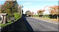
2
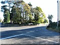
The B7 at the Burren cross roads
The B7 approaches the junction from the North and then swings eastwards towards Warrenpoint along Upper Dromore Road.
Image: © Eric Jones
Taken: 7 Nov 2016
0.09 miles
3
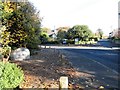
The B7 (Mayobridge to Warrenpoint) road from the end of Mound Road
Image: © Eric Jones
Taken: 7 Nov 2016
0.09 miles
4
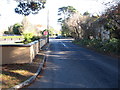
Mound road at its junction with the B7
The B7 is the Mayobridge to Warrenpoint Road.
Image: © Eric Jones
Taken: 7 Nov 2016
0.10 miles
5
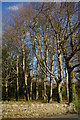
Woods on Mound Road
A small stream flows through this pretty copse of (mainly) ash trees
Image: © David Crozier
Taken: 14 Apr 2008
0.12 miles
6
View north-west along the Greenan Road
The industrial units on the right are in the Milltown Industrial Estate. The Greenan Road links Warrenpoint with Newry. Nowadays, most traffic between the two centres use the A2 Dual Carriageway.
Image: © Eric Jones
Taken: 7 Nov 2016
0.13 miles
7

Units on the Milltown Industrial Estate, Greenan Road
This out of town estate has a number of manufacturing and retail units.
Image: © Eric Jones
Taken: 7 Nov 2016
0.19 miles