IMAGES TAKEN NEAR TO
Dallan View, NEWRY, BT34 3SL
Introduction
This page details the photographs taken nearby to Dallan View, BT34 3SL by members of the Geograph project.
The Geograph project started in 2005 with the aim of publishing, organising and preserving representative images for every square kilometre of Great Britain, Ireland and the Isle of Man.

There are currently over 7.5m images from over14,400 individuals and you can help contribute to the project by visiting https://www.geograph.org.uk
Image Map
Images are licensed for reuse under creativecommons.org/licenses/by-sa/2.0
Notes
- Clicking on the map will re-center to the selected point.
- The higher the marker number, the further away the image location is from the centre of the postcode.
Image Listing (12 Images Found)
Images are licensed for reuse under creativecommons.org/licenses/by-sa/2.0
Image
Details
Distance
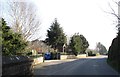
1
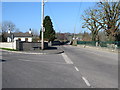
View north along Clonallan Road from its junction with Donaghaguy Road
Image: © Eric Jones
Taken: 19 Feb 2013
0.18 miles
2
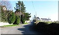
View south along the upper section of Rath Road
This is part of the urban fringe of the town of Warrenpoint.
Image: © Eric Jones
Taken: 19 Feb 2013
0.19 miles
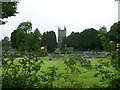
3
A scaffolded Clonallon Church from Donaghaguy Road
http://www.chrono.qub.ac.uk/local/down/Clonallon/
Image: © Eric Jones
Taken: 19 Feb 2013
0.19 miles
4
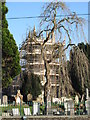
A weeping willow in the graveyard of Clonallon Church (CoI)
Image: © Eric Jones
Taken: 19 Feb 2013
0.19 miles
5
The main entrance to Annett's Garden Centre on Rath Road
Image: © Eric Jones
Taken: 19 Feb 2013
0.20 miles
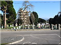
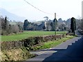
6
The new burial ground of Clonallon CoI Parish Church
The tower of this 17thC church can be seen through the trees.
http://www.chrono.qub.ac.uk/local/down/Clonallon/
Image: © Eric Jones
Taken: 3 Jul 2012
0.21 miles
7
Clonallon Church from the Ballymaconaghy Road junction on the Donaghaguy Road
Image: © Eric Jones
Taken: 19 Feb 2013
0.21 miles
8
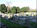
The cemetery attached to Clonallon Cof I Church, Warrenpoint
The church can be seen between the trees on the left.
Image: © Eric Jones
Taken: 19 Feb 2013
0.21 miles
9

The Sweet Pea cafe and restaurant at Annett's Garden Centre
Image: © Eric Jones
Taken: 3 Jul 2012
0.22 miles
10
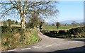
Ballymaconaghy Road at its junction with Donaghaguy Road
These are minor country roads on the fringe of the port of Warrenpoint.
Image: © Eric Jones
Taken: 19 Feb 2013
0.23 miles