IMAGES TAKEN NEAR TO
Clonallon Road, NEWRY, BT34 3QN
Introduction
This page details the photographs taken nearby to Clonallon Road, BT34 3QN by members of the Geograph project.
The Geograph project started in 2005 with the aim of publishing, organising and preserving representative images for every square kilometre of Great Britain, Ireland and the Isle of Man.

There are currently over 7.5m images from over14,400 individuals and you can help contribute to the project by visiting https://www.geograph.org.uk
Image Map
Images are licensed for reuse under creativecommons.org/licenses/by-sa/2.0
Notes
- Clicking on the map will re-center to the selected point.
- The higher the marker number, the further away the image location is from the centre of the postcode.
Image Listing (13 Images Found)
Images are licensed for reuse under creativecommons.org/licenses/by-sa/2.0
Image
Details
Distance
1
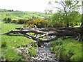
Tributary of the Moygannon River
Just below Clontifleece Primary School, looking downstream into the main Moygannon valley.
Image: © Oliver Dixon
Taken: 12 May 2007
0.02 miles
3
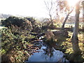
Almost ten years on and the fallen tree still bridges the Aghavilly stream
Oliver Dixon photographed the same tree in 2007. It is interesting to see the amount of growth in the whins.
Image]
Image: © Eric Jones
Taken: 23 Nov 2016
0.11 miles
4
Powerlines approaching the Clonallon Road from the west
Image: © Eric Jones
Taken: 23 Nov 2016
0.11 miles
5
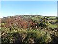
Trees on the floodplain of the middle Moygannon River Valley
Image: © Eric Jones
Taken: 23 Nov 2016
0.12 miles
6
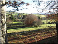
Woodland between the Clonallon Road and the Moygannon River
Image: © Eric Jones
Taken: 23 Nov 2016
0.17 miles
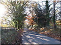
7

Bungalow on the Moygannon Road
Inland from Warrenpoint.
Image: © Oliver Dixon
Taken: 12 May 2007
0.17 miles
8
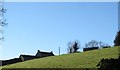
Farmhouse and out-buildings on a drumlin above the Clonallon Road
Image: © Eric Jones
Taken: 23 Nov 2016
0.20 miles
9
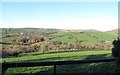
Drumlins in the upper Moygannon River basin
Image: © Eric Jones
Taken: 23 Nov 2016
0.20 miles
10
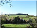
Drumlin top shelter belt above the Clonallon Road
Image: © Eric Jones
Taken: 23 Nov 2016
0.21 miles