IMAGES TAKEN NEAR TO
The Docks, NEWRY, BT34 3JR
Introduction
This page details the photographs taken nearby to The Docks, BT34 3JR by members of the Geograph project.
The Geograph project started in 2005 with the aim of publishing, organising and preserving representative images for every square kilometre of Great Britain, Ireland and the Isle of Man.

There are currently over 7.5m images from over14,400 individuals and you can help contribute to the project by visiting https://www.geograph.org.uk
Image Map
Images are licensed for reuse under creativecommons.org/licenses/by-sa/2.0
Notes
- Clicking on the map will re-center to the selected point.
- The higher the marker number, the further away the image location is from the centre of the postcode.
Image Listing (106 Images Found)
Images are licensed for reuse under creativecommons.org/licenses/by-sa/2.0
Image
Details
Distance
1
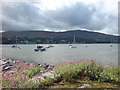
The South from Warrenpoint across the lough
A view of just south of Omeath across the lough from Warrenpoint.
Image: © Raymond McSherry
Taken: 1 Sep 2007
0.03 miles
2
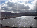
The sun on Carlingford Lough
This is just a nice photo of the sun on Carlingford Lough in a lovely peaceful setting.
Image: © Raymond McSherry
Taken: 1 Sep 2007
0.03 miles
3
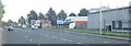
Original Factory Shop, Warrenpoint
This is located next to the Docks Estate on the A2 on the western outskirts of the town.
Image: © Eric Jones
Taken: 24 Sep 2018
0.06 miles
4
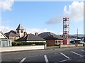
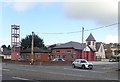
Fire Station Tower at Warrenpoint
The town's fire station stands at the junction of the A2 and Meeting Street and is opposite Warrenpoint Harbour. The spire in the background is at Warrenpoint Presbyterian Church in Meeting Street.
Image: © Eric Jones
Taken: 16 Oct 2019
0.07 miles
5
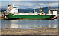
The "RR Challenge" at Warrenpoint
See Image Under the former name of “RR Challenge”, the “Clipper Ranger” operated for Seatruck, from Warrenpoint where she is seen loading for Heysham. See also Image
Image: © Albert Bridge
Taken: 20 Aug 2006
0.09 miles
6
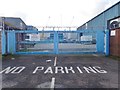
Warrenpoint Fire and Rescue Service Station
This faces onto Meeting Street and adjoins Warrenpoint Presbyterian Church.
Image: © Eric Jones
Taken: 16 Oct 2019
0.10 miles
8
Fire Station drill tower in Charlotte Street
Image: © Eric Jones
Taken: 11 May 2010
0.10 miles
9
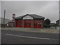
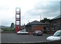
Warrenpoint Fire Station
Meeting Street
Image: © HENRY CLARK
Taken: 14 Oct 2009
0.10 miles
10
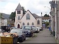
Warrenpoint Presbyterian Church, Meeting Street, Warrenpoint
The Warrenpoint Congregation was formed by Gaelic-speaking Scottish Highlander planters in the late 17thC. In 1830 the then minister and some of the congregation joined the Remonstrant Synod, which later became the Non-Subscribing Presbyterian Church (a body whose beliefs are broadly akin to those of the Unitarian Church). Those who remained built the present meeting house in Meeting Street, which was enlarged in the 1880s. Many Presbyterians left the area during The Troubles of the 1970s, 80s and 90s. This image was taken from Charlotte Street.
Image: © Eric Jones
Taken: 16 Oct 2019
0.11 miles