IMAGES TAKEN NEAR TO
Ashgrove Terrace, NEWRY, BT34 3JF
Introduction
This page details the photographs taken nearby to Ashgrove Terrace, BT34 3JF by members of the Geograph project.
The Geograph project started in 2005 with the aim of publishing, organising and preserving representative images for every square kilometre of Great Britain, Ireland and the Isle of Man.

There are currently over 7.5m images from over14,400 individuals and you can help contribute to the project by visiting https://www.geograph.org.uk
Image Map
Images are licensed for reuse under creativecommons.org/licenses/by-sa/2.0
Notes
- Clicking on the map will re-center to the selected point.
- The higher the marker number, the further away the image location is from the centre of the postcode.
Image Listing (126 Images Found)
Images are licensed for reuse under creativecommons.org/licenses/by-sa/2.0
Image
Details
Distance
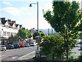
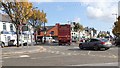
3
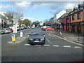
Dromore Road at its junction with the A2 in the centre of Warrenpoint
Image: © Eric Jones
Taken: 16 Oct 2019
0.06 miles
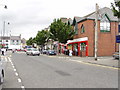
5
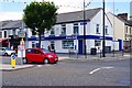
Ulster Bank, 2 Charlotte Street, Warrenpoint, Co. Down
Located on the corner of Charlotte Street and Upper Dromore Road (part of the B7), the bank is part of The Royal Bank of Scotland Group.
Image: © P L Chadwick
Taken: 17 Jun 2017
0.09 miles
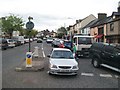
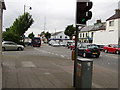
8
Traffic Roundabout in the Centre of Warrenpoint
This is at the junction of the A2 and the B7.
Image: © Eric Jones
Taken: 16 Oct 2019
0.10 miles