IMAGES TAKEN NEAR TO
St. Brigids Cottages, NEWRY, BT34 3HE
Introduction
This page details the photographs taken nearby to St. Brigids Cottages, BT34 3HE by members of the Geograph project.
The Geograph project started in 2005 with the aim of publishing, organising and preserving representative images for every square kilometre of Great Britain, Ireland and the Isle of Man.

There are currently over 7.5m images from over14,400 individuals and you can help contribute to the project by visiting https://www.geograph.org.uk
Image Map
Images are licensed for reuse under creativecommons.org/licenses/by-sa/2.0
Notes
- Clicking on the map will re-center to the selected point.
- The higher the marker number, the further away the image location is from the centre of the postcode.
Image Listing (9 Images Found)
Images are licensed for reuse under creativecommons.org/licenses/by-sa/2.0
Image
Details
Distance
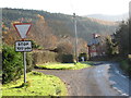
1
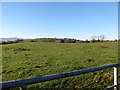
Drumlin topography south of the Levallyreagh Road
The hills in the background are the Cooley Mountains of the Irish Republic.
Image: © Eric Jones
Taken: 23 Nov 2016
0.17 miles
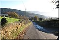
2
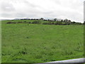
View south across grassland from the Lavallyreagh Road
The hills in the background are in what many of the older folk still call "The Free State". That was the country's official name between 1922 and 1927.
Image: © Eric Jones
Taken: 5 Sep 2011
0.17 miles
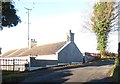
4
Farmstead cottage on the Levallyreagh Road
Image: © Eric Jones
Taken: 5 Sep 2011
0.20 miles
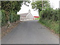
5
Levallyreagh Road 100 yards from the T-junction
Image: © Eric Jones
Taken: 23 Nov 2016
0.22 miles
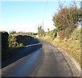
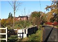
6
Levallyreagh Road descending towards the junction with Greenpark Road
Image: © Eric Jones
Taken: 23 Nov 2016
0.22 miles
7
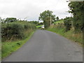
View north westwards along Levallyreagh Road
This is a rural by-way which eventually leads of the hills to Mayobridge.
Image: © Eric Jones
Taken: 5 Sep 2011
0.24 miles
8
View north-westwards along Levallyreagh Road
Image: © Eric Jones
Taken: 23 Nov 2016
0.24 miles
9
Building site on the Greenpark Road
This is located below the junction with Levallyreagh Road.
Image: © Eric Jones
Taken: 23 Nov 2016
0.24 miles