IMAGES TAKEN NEAR TO
Greenpark Court, NEWRY, BT34 3GS
Introduction
This page details the photographs taken nearby to Greenpark Court, BT34 3GS by members of the Geograph project.
The Geograph project started in 2005 with the aim of publishing, organising and preserving representative images for every square kilometre of Great Britain, Ireland and the Isle of Man.

There are currently over 7.5m images from over14,400 individuals and you can help contribute to the project by visiting https://www.geograph.org.uk
Image Map
Images are licensed for reuse under creativecommons.org/licenses/by-sa/2.0
Notes
- Clicking on the map will re-center to the selected point.
- The higher the marker number, the further away the image location is from the centre of the postcode.
Image Listing (105 Images Found)
Images are licensed for reuse under creativecommons.org/licenses/by-sa/2.0
Image
Details
Distance
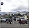
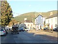
1
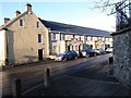
Kilbroney Court, Rostrevor
These houses are located in the centre of the village being at the junction of Warrenpoint Road and Greenpark Road.
Image: © Eric Jones
Taken: 23 Nov 2016
0.04 miles
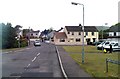
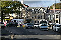
4
Warrenpoint Road, Rostrevor
This is an eastward view in the direction of The Square.
Image: © Eric Jones
Taken: 9 Sep 2011
0.06 miles
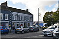
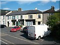
6
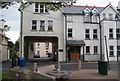
Apartment block on the Square at Rostrevor
Image: © Eric Jones
Taken: 11 May 2010
0.07 miles