IMAGES TAKEN NEAR TO
Carrickree, NEWRY, BT34 3FA
Introduction
This page details the photographs taken nearby to Carrickree, BT34 3FA by members of the Geograph project.
The Geograph project started in 2005 with the aim of publishing, organising and preserving representative images for every square kilometre of Great Britain, Ireland and the Isle of Man.

There are currently over 7.5m images from over14,400 individuals and you can help contribute to the project by visiting https://www.geograph.org.uk
Image Map
Images are licensed for reuse under creativecommons.org/licenses/by-sa/2.0
Notes
- Clicking on the map will re-center to the selected point.
- The higher the marker number, the further away the image location is from the centre of the postcode.
Image Listing (6 Images Found)
Images are licensed for reuse under creativecommons.org/licenses/by-sa/2.0
Image
Details
Distance
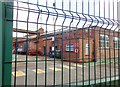
1
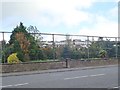
Safety fencing between Warrenpoint Golf Course and the A2
This is to avoid contact between stray golf balls and passing road traffic.
Image: © Eric Jones
Taken: 16 Oct 2019
0.21 miles
2
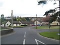
Lower Dromore Road, Warrenpoint at its junction with the A2
Image: © Eric Jones
Taken: 11 May 2010
0.21 miles
3
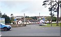
The Lower Dromore Road junction on the A2 at Warrenpoint
This junction faces the docks.
Image: © Eric Jones
Taken: 16 Oct 2019
0.24 miles
4
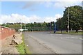
The Dock Road at its junction with the A2 at Warrenpoint
Image: © Eric Jones
Taken: 16 Oct 2019
0.24 miles
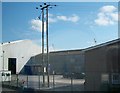
6
Industrial units at the Port of Warrenpoint
Image: © Eric Jones
Taken: 16 Oct 2019
0.25 miles