IMAGES TAKEN NEAR TO
Roxburgh Place, NEWRY, BT34 3EW
Introduction
This page details the photographs taken nearby to Roxburgh Place, BT34 3EW by members of the Geograph project.
The Geograph project started in 2005 with the aim of publishing, organising and preserving representative images for every square kilometre of Great Britain, Ireland and the Isle of Man.

There are currently over 7.5m images from over14,400 individuals and you can help contribute to the project by visiting https://www.geograph.org.uk
Image Map
Images are licensed for reuse under creativecommons.org/licenses/by-sa/2.0
Notes
- Clicking on the map will re-center to the selected point.
- The higher the marker number, the further away the image location is from the centre of the postcode.
Image Listing (122 Images Found)
Images are licensed for reuse under creativecommons.org/licenses/by-sa/2.0
Image
Details
Distance
2
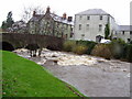
The Kilbroney River
In full flow taken from the Fairy Glen at Rostrevor
Image: © HENRY CLARK
Taken: 22 Sep 2007
0.04 miles
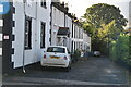
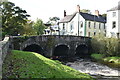
7
The Bridge Street bridge over the Kilbroney River
This image was taken from Water Street.
Image: © Eric Jones
Taken: 27 Feb 2013
0.05 miles
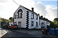
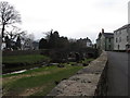
9
The lower end of Cloughmore Road leading to the bridge
The Kilbroney Forest Park can be seen in the background.
Image: © Eric Jones
Taken: 5 Sep 2011
0.06 miles
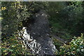
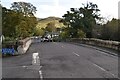
10
Approaching the bridge over the Rostrevor River
This view
Image: © Eric Jones
Taken: 4 Jun 2012
0.06 miles