IMAGES TAKEN NEAR TO
Church Street, NEWRY, BT34 3BB
Introduction
This page details the photographs taken nearby to Church Street, BT34 3BB by members of the Geograph project.
The Geograph project started in 2005 with the aim of publishing, organising and preserving representative images for every square kilometre of Great Britain, Ireland and the Isle of Man.

There are currently over 7.5m images from over14,400 individuals and you can help contribute to the project by visiting https://www.geograph.org.uk
Image Map
Images are licensed for reuse under creativecommons.org/licenses/by-sa/2.0
Notes
- Clicking on the map will re-center to the selected point.
- The higher the marker number, the further away the image location is from the centre of the postcode.
Image Listing (113 Images Found)
Images are licensed for reuse under creativecommons.org/licenses/by-sa/2.0
Image
Details
Distance
1
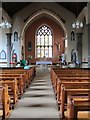
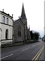
The nave and sanctuary of St Mary, Star of the Sea, Rostrevor
This church dates from the early 1840s.
Image: © Eric Jones
Taken: 4 Jun 2012
0.00 miles
2
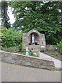
Marian Grotto at St Mary, Star of the Sea, Rostrevor
Image: © Eric Jones
Taken: 4 Jun 2012
0.01 miles
3
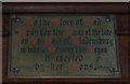
The Ross of Bladenberg Plaque at St Mary's Star of the Sea
The Rosses of Bladenberg (the family of the late Major General Robert Ross) were converts to Catholicism. They remained, however, staunchly Loyalist and Unionist. In the second half of the 19thC they were regarded not only as one of Ireland's most prominent Catholic family but also one of the most vehemently anti-nationalist.
Image: © Eric Jones
Taken: 4 Jun 2012
0.01 miles
4
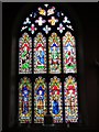
The east window at St Mary, Star of the Sea, Rostrevor
Image: © Eric Jones
Taken: 4 Jun 2012
0.01 miles
5
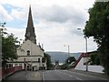
The steeple of the Catholic church and the tower of the Anglican church at Rostrevor
Both churches are located in Church Street. The Catholic church is St Mary's Star of the Sea, consecrated in 1854 and replaced a small 18th century mass house. The building in the foreground left is the Convent of Mercy. The Anglican church appears not to be dedicated to any particular saint and is known simply as Rostrevor Church of Ireland. The latter dates from 1744.
Image: © Eric Jones
Taken: 4 Jun 2012
0.01 miles
6
The Convent of Mercy Primary School, Mary Street, Rostrevor
Image: © Eric Jones
Taken: 27 Feb 2013
0.03 miles
7
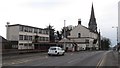
St Mary Star of the Sea Catholic Church, Mary Street, Rostrevor
Some 93% of the population of Rostrevor come from a Catholic Community background.
Image: © Eric Jones
Taken: 27 Feb 2013
0.03 miles
8
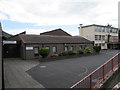
The Convent of Mercy Primary School, Rostrevor
This school is located next to the parish church.
Image: © Eric Jones
Taken: 4 Jun 2012
0.05 miles
9
Parish Centre in Church Street, Rostrevor
This is located opposite St Mary's Star of the Sea Church.
Image: © Eric Jones
Taken: 4 Jun 2012
0.05 miles
10
The Old School House Coffee Shop, Church Street, Rostrevor
This shop, as the name suggests, occupies the former Victorian school room. When Google Street View visited the village in 2008 the building was derelict.
Image: © Eric Jones
Taken: 12 Mar 2013
0.07 miles