IMAGES TAKEN NEAR TO
Carrick Close, NEWRY, BT34 3AT
Introduction
This page details the photographs taken nearby to Carrick Close, BT34 3AT by members of the Geograph project.
The Geograph project started in 2005 with the aim of publishing, organising and preserving representative images for every square kilometre of Great Britain, Ireland and the Isle of Man.

There are currently over 7.5m images from over14,400 individuals and you can help contribute to the project by visiting https://www.geograph.org.uk
Image Map
Images are licensed for reuse under creativecommons.org/licenses/by-sa/2.0
Notes
- Clicking on the map will re-center to the selected point.
- The higher the marker number, the further away the image location is from the centre of the postcode.
Image Listing (6 Images Found)
Images are licensed for reuse under creativecommons.org/licenses/by-sa/2.0
Image
Details
Distance
1
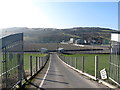
St Mary's GAA Club, Burren, Co. Down
The grounds lie on the north side of Burren and on the valley floor between the Bridge Road and the Carrogs Road.
Image: © Eric Jones
Taken: 19 Feb 2013
0.13 miles
2
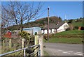
Farm house and buildings above the Bridge Road in Carrickmacstay TD
Image: © Eric Jones
Taken: 19 Feb 2013
0.15 miles
3
Carrick Primary School, Burren
This is a recently built primary school, having replaced a near-by older building. It is a state-financed school with a Catholic ethos.
Image: © Eric Jones
Taken: 19 Feb 2013
0.16 miles
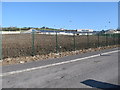
4
Practice pitches at the Burren GAA ground
Image: © Eric Jones
Taken: 19 Feb 2013
0.22 miles
5
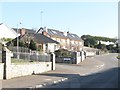
New houses at Carrick Brae off Ballydesland Road, Burren
Image: © Eric Jones
Taken: 19 Feb 2013
0.23 miles
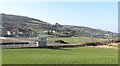
6
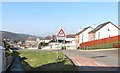
Approaching Carrick Primary School along Ballydesland Road, Burren
Image: © Eric Jones
Taken: 19 Feb 2013
0.23 miles