IMAGES TAKEN NEAR TO
Carneny Grove, NEWRY, BT34 2TB
Introduction
This page details the photographs taken nearby to Carneny Grove, BT34 2TB by members of the Geograph project.
The Geograph project started in 2005 with the aim of publishing, organising and preserving representative images for every square kilometre of Great Britain, Ireland and the Isle of Man.

There are currently over 7.5m images from over14,400 individuals and you can help contribute to the project by visiting https://www.geograph.org.uk
Image Map
Images are licensed for reuse under creativecommons.org/licenses/by-sa/2.0
Notes
- Clicking on the map will re-center to the selected point.
- The higher the marker number, the further away the image location is from the centre of the postcode.
Image Listing (50 Images Found)
Images are licensed for reuse under creativecommons.org/licenses/by-sa/2.0
Image
Details
Distance
1
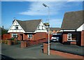
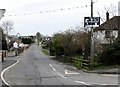
Houses on the eastern outskirts of Mayobridge
Image: © Eric Jones
Taken: 25 Sep 2017
0.03 miles
2
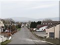
View westwards along Old Road, Mayobridge
The building with the roof lights is the Youth and Community Centre.
Image: © Eric Jones
Taken: 14 Feb 2012
0.03 miles
3
Mayobridge Youth and Community Centre, Old Road, Mayobridge
Image: © Eric Jones
Taken: 14 Feb 2012
0.04 miles
4
Hilltown Road on the eastern outskirts of Mayobridge
Image: © Eric Jones
Taken: 14 Feb 2012
0.05 miles
5
Dissident Republican Poster on the corner of Hilltown Road and Old Road
The signs were apparently erected by the Newry/South Armagh Republican Prisoners Support Group. Maghaberry is Northern Ireland's main prison. Dissent Republicans are seeking POW status and their protest has cost the state in excess of £1million.
http://www.belfasttelegraph.co.uk/opinion/columnists/eamon-mccann/theres-no-end-in-sight-for-maghaberry-prison-dispute-16084974.html
Image: © Eric Jones
Taken: 14 Feb 2012
0.05 miles
6
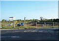
Housing Development Site at the junction of Old Road and the B8
Large detached houses are to be built on this site. Work is an initial stage. Mayobridge, Hilltown, Rathfriland and, to a lesser extent, Kilcoo have seen extensive private housing projects since 2000 as these town have increasingly become dormitory towns for Newry.
Image: © Eric Jones
Taken: 14 May 2010
0.05 miles
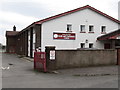
7
Spar store at the eastern outskirts of Mayobridge
Image: © Eric Jones
Taken: 30 Jun 2011
0.05 miles
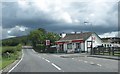
8

Vivo Store at Mayobridge
This village store is located on the B8 (Hilltown Road).
Image: © Eric Jones
Taken: 9 Jun 2021
0.06 miles
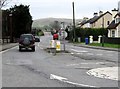
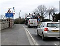
9
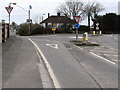
Mini roundabout in Hilltown Road, Mayobridge
Image: © Eric Jones
Taken: 14 Feb 2012
0.06 miles
10
Congested mini roundabout in Hilltown Road, Mayobridge
Image: © Eric Jones
Taken: 14 Feb 2012
0.06 miles