IMAGES TAKEN NEAR TO
Fern Court, NEWRY, BT34 2SR
Introduction
This page details the photographs taken nearby to Fern Court, BT34 2SR by members of the Geograph project.
The Geograph project started in 2005 with the aim of publishing, organising and preserving representative images for every square kilometre of Great Britain, Ireland and the Isle of Man.

There are currently over 7.5m images from over14,400 individuals and you can help contribute to the project by visiting https://www.geograph.org.uk
Image Map
Images are licensed for reuse under creativecommons.org/licenses/by-sa/2.0
Notes
- Clicking on the map will re-center to the selected point.
- The higher the marker number, the further away the image location is from the centre of the postcode.
Image Listing (24 Images Found)
Images are licensed for reuse under creativecommons.org/licenses/by-sa/2.0
Image
Details
Distance
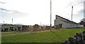
1
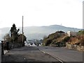
The Municipal Cemetery entrance on Monks Hill Road
The entrance is located on the ridge of a glacially deposited drumlin. From this point the land descends south-westwards into the Newry River valley.
Image: © Eric Jones
Taken: 30 Nov 2016
0.05 miles
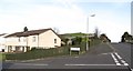
2
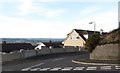
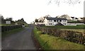
Fern Court at its junction with Monks Hill Road
Image: © Eric Jones
Taken: 30 Nov 2016
0.06 miles
3
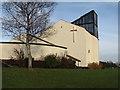
Chapel at Monks Hill Municipal Cemetery, Newry
Image: © Eric Jones
Taken: 30 Nov 2016
0.08 miles
4
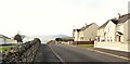
Houses on Crieve Heights
These face the Cemetery Chapel across Monks Hill Road.
Image: © Eric Jones
Taken: 30 Nov 2016
0.08 miles
5
Cemetery chapel at Monks Hill Municipal Cemetery, Newry
Image: © Eric Jones
Taken: 30 Nov 2016
0.08 miles
6
The junction of Fern Heights and Monk Hill Road
Beyond, directly below the speed restriction signs, is the entrance into Fern Court.
Image: © Eric Jones
Taken: 30 Nov 2016
0.09 miles
7
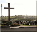
The main crucifix at Monks Hill Municipal Cemetery, Newry
This is situated on high ground overlooking the city.
Image: © Eric Jones
Taken: 30 Nov 2016
0.09 miles
8
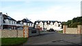
Gleann na Manach off Monks Hill Road
This is an attractive court of recently built houses.
Image: © Eric Jones
Taken: 30 Nov 2016
0.12 miles
9
New houses on Crieve Heights, Newry
These are located on the ridge of a drumlin on the north side of Monks Hill Road.
Image: © Eric Jones
Taken: 30 Nov 2016
0.12 miles
10
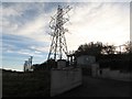
Pylon supporting power cables reaching the Monks Hill Road sub-station, Newry
Image: © Eric Jones
Taken: 30 Nov 2016
0.12 miles