IMAGES TAKEN NEAR TO
Warren Hill, NEWRY, BT34 2PH
Introduction
This page details the photographs taken nearby to Warren Hill, BT34 2PH by members of the Geograph project.
The Geograph project started in 2005 with the aim of publishing, organising and preserving representative images for every square kilometre of Great Britain, Ireland and the Isle of Man.

There are currently over 7.5m images from over14,400 individuals and you can help contribute to the project by visiting https://www.geograph.org.uk
Image Map
Images are licensed for reuse under creativecommons.org/licenses/by-sa/2.0
Notes
- Clicking on the map will re-center to the selected point.
- The higher the marker number, the further away the image location is from the centre of the postcode.
Image Listing (7 Images Found)
Images are licensed for reuse under creativecommons.org/licenses/by-sa/2.0
Image
Details
Distance
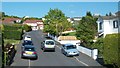
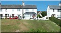
1
Bungalows in Warren Hill, off Old Warrenpoint Road
Image: © Eric Jones
Taken: 25 May 2010
0.05 miles
2
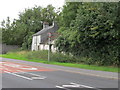
Derelict House on the Old Warrenpoint Road
This relict from the past is surrounded by modern estates.
Image: © Eric Jones
Taken: 14 Sep 2011
0.06 miles
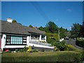
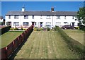
3
The eastern end of the Greenwood Drive Estate
Image: © Eric Jones
Taken: 25 May 2010
0.07 miles
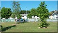
4
Terraced houses above Old Warrenpoint Road
Image: © Eric Jones
Taken: 25 May 2010
0.08 miles
6
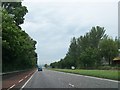
View north along the dual-carriageway Warrenpoint Road
This fast road links Newry and Warrenpoint.
Image: © Eric Jones
Taken: 19 Jun 2013
0.19 miles