IMAGES TAKEN NEAR TO
Crieve Court, NEWRY, BT34 2PE
Introduction
This page details the photographs taken nearby to Crieve Court, BT34 2PE by members of the Geograph project.
The Geograph project started in 2005 with the aim of publishing, organising and preserving representative images for every square kilometre of Great Britain, Ireland and the Isle of Man.

There are currently over 7.5m images from over14,400 individuals and you can help contribute to the project by visiting https://www.geograph.org.uk
Image Map
Images are licensed for reuse under creativecommons.org/licenses/by-sa/2.0
Notes
- Clicking on the map will re-center to the selected point.
- The higher the marker number, the further away the image location is from the centre of the postcode.
Image Listing (22 Images Found)
Images are licensed for reuse under creativecommons.org/licenses/by-sa/2.0
Image
Details
Distance
1
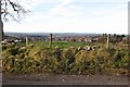
The City of Newry from the middle section of Monks Hill Road
Image: © Eric Jones
Taken: 30 Nov 2016
0.07 miles
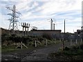
2
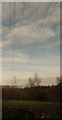
Overhead lines supplying the Monks Hill Electricity Sub-Station
Image: © Eric Jones
Taken: 30 Nov 2016
0.14 miles
3
New houses on Crieve Heights, Newry
These are located on the ridge of a drumlin on the north side of Monks Hill Road.
Image: © Eric Jones
Taken: 30 Nov 2016
0.15 miles
4
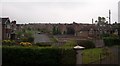
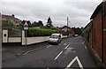
Private housing estate at Knockdarragh, Newry
Image: © Eric Jones
Taken: 7 May 2011
0.18 miles
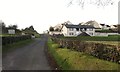
5
The Western End of Crieve Road, Newry
This once rural road is now lined with new housing developments.
Image: © Eric Jones
Taken: 17 Jul 2010
0.18 miles
6
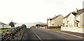
Houses on Crieve Heights
These face the Cemetery Chapel across Monks Hill Road.
Image: © Eric Jones
Taken: 30 Nov 2016
0.18 miles
7
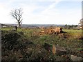
Fallen tree on the north side of Monks Hill Road
Image: © Eric Jones
Taken: 30 Nov 2016
0.19 miles
9
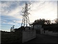
Pylon supporting power cables reaching the Monks Hill Road sub-station, Newry
Image: © Eric Jones
Taken: 30 Nov 2016
0.19 miles
10
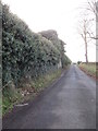
Ivy clad walls on Monks Hill Road enclosing the Crieve House grange
Image: © Eric Jones
Taken: 30 Nov 2016
0.21 miles