IMAGES TAKEN NEAR TO
Warrenpoint Road, NEWRY, BT34 2PD
Introduction
This page details the photographs taken nearby to Warrenpoint Road, BT34 2PD by members of the Geograph project.
The Geograph project started in 2005 with the aim of publishing, organising and preserving representative images for every square kilometre of Great Britain, Ireland and the Isle of Man.

There are currently over 7.5m images from over14,400 individuals and you can help contribute to the project by visiting https://www.geograph.org.uk
Image Map
Images are licensed for reuse under creativecommons.org/licenses/by-sa/2.0
Notes
- Clicking on the map will re-center to the selected point.
- The higher the marker number, the further away the image location is from the centre of the postcode.
Image Listing (74 Images Found)
Images are licensed for reuse under creativecommons.org/licenses/by-sa/2.0
Image
Details
Distance
1
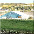
The Modern Fireplace Centre, Greenbank Estate, Newry
Image: © Eric Jones
Taken: 12 May 2018
0.04 miles
2
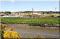
Levee on the banks of the Newry River
This image taken from the Newry Greenway shows a flood prevention levee built to protect units on the Greenbank Industrial estate.
Image: © Eric Jones
Taken: 12 May 2018
0.06 miles
3

Levee on the banks of the Newry River
This image taken from the Newry Greenway shows a flood prevention levee built to protect units on the Greenbank Industrial estate.
Image: © Eric Jones
Taken: 12 May 2018
0.06 miles
4
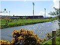
Pairc Esler GAA Stadium
This is the home of Newry Shamrocks. The stadium is located on the Greenbank Estate an area of reclaimed land between the A2 and the Newry River. The image was taken from the Newry Greenway,
Image: © Eric Jones
Taken: 12 May 2018
0.09 miles
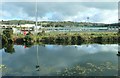
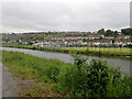
5
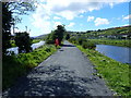
The Middlebank between the Newry River and the Newry Ship Canal
On the opposite bank of the river is a GAA Stadium (Pairc Esler) and on the opposite side of the canal is a soccer pitch.
Image: © Eric Jones
Taken: 12 May 2018
0.10 miles
6
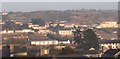
St Mary's RC Church off Warrenpoint Road from Dublin Road
St Mary's Church and its large burial ground stands at the centre of the photo. The large building in the middleground right is St Mary's Secondary School.
Image: © Eric Jones
Taken: 18 Feb 2010
0.10 miles
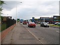
7
Business units on the Warrenpoint Road
The image was taken from the Old Warrenpoint Road.
Image: © Eric Jones
Taken: 20 Aug 2019
0.12 miles
9
P?irc Esler - the home of the Down Gaelic football and hurling teams and the Newry Shamrocks GAA club.
The stadium here is viewed across the Newry Canal and Newry River from the Fathom Line
Image: © Eric Jones
Taken: 29 Oct 2019
0.13 miles
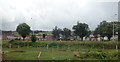
10
Drumalane Park Playing Fields, Newry
The image was taken across the Newry Canal from the Greenway.
Image: © Eric Jones
Taken: 9 Jun 2021
0.13 miles