IMAGES TAKEN NEAR TO
Whinnbloom Villas, NEWRY, BT34 2NP
Introduction
This page details the photographs taken nearby to Whinnbloom Villas, BT34 2NP by members of the Geograph project.
The Geograph project started in 2005 with the aim of publishing, organising and preserving representative images for every square kilometre of Great Britain, Ireland and the Isle of Man.

There are currently over 7.5m images from over14,400 individuals and you can help contribute to the project by visiting https://www.geograph.org.uk
Image Map
Images are licensed for reuse under creativecommons.org/licenses/by-sa/2.0
Notes
- Clicking on the map will re-center to the selected point.
- The higher the marker number, the further away the image location is from the centre of the postcode.
Image Listing (61 Images Found)
Images are licensed for reuse under creativecommons.org/licenses/by-sa/2.0
Image
Details
Distance
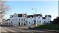
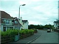
1
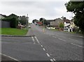
Chapel Hill from the junction with Mayo Road
Image: © Eric Jones
Taken: 14 Sep 2011
0.01 miles
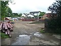
3
Unnamed close on the western outskirts of Mayobridge
The houses on rising ground in the background are in Chapel Hill Road.
Image: © Eric Jones
Taken: 17 Jul 2010
0.04 miles

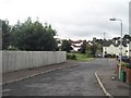
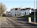
6
Terraced housing on the corner of Chapel Hill and Mayo Road
Image: © Eric Jones
Taken: 19 Feb 2013
0.05 miles
7
Modern terraced housing at the bottom of Chapel Hill
Image: © Eric Jones
Taken: 19 Feb 2013
0.06 miles
8
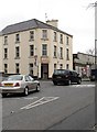
Barber's Shop on the corner of Chapel Hill and the B8 at Mayobridge
Image: © Eric Jones
Taken: 14 Feb 2012
0.06 miles
9
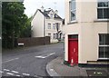
Chapel Hill at its junction with the B8 at Mayobridge
Image: © Eric Jones
Taken: 7 May 2011
0.07 miles
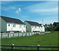
10
Houses on the Aifreann Estate
Mayobridge is increasingly becoming a dormitory settlement of Newry.
Image: © Eric Jones
Taken: 2 Jul 2010
0.07 miles