IMAGES TAKEN NEAR TO
Bettys Hill Road, NEWRY, BT34 2LZ
Introduction
This page details the photographs taken nearby to Bettys Hill Road, BT34 2LZ by members of the Geograph project.
The Geograph project started in 2005 with the aim of publishing, organising and preserving representative images for every square kilometre of Great Britain, Ireland and the Isle of Man.

There are currently over 7.5m images from over14,400 individuals and you can help contribute to the project by visiting https://www.geograph.org.uk
Image Map
Images are licensed for reuse under creativecommons.org/licenses/by-sa/2.0
Notes
- Clicking on the map will re-center to the selected point.
- The higher the marker number, the further away the image location is from the centre of the postcode.
Image Listing (13 Images Found)
Images are licensed for reuse under creativecommons.org/licenses/by-sa/2.0
Image
Details
Distance
1
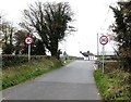
Entering the village of Ballyholland along Betty's Hill Road
The entrance to Pairc Ui Loingsigh GAA Club Grounds is on the left immediately after the speed restriction signs.
Image: © Eric Jones
Taken: 7 Nov 2016
0.02 miles
2
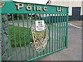
Dogs Not Allowed by Order of Committee - sign on the gates of Pairc Ui Loingsigh
Image: © Eric Jones
Taken: 7 Nov 2016
0.07 miles
3
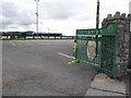
Car park at Pairc Ui Loingsigh GAA Club, Ballyholland
Image: © Eric Jones
Taken: 7 Nov 2016
0.08 miles
4
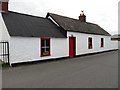
Renovated buildings at Pairc Ui Loingsigh
This faces on to the Betty's Hill Road.
Image: © Eric Jones
Taken: 7 Nov 2016
0.09 miles
5
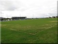
GAA pitch at Pairc Ui Loingsigh, Ballyholland
Image: © Eric Jones
Taken: 7 Nov 2016
0.14 miles
6
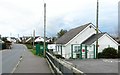
Rascals 'N Ruffians Playgroup Centre at Ballyholland
This located at the junction of Billy's Road and Betty's Hill Road and opposite the Ballyholland Community Centre.
Image: © Eric Jones
Taken: 7 Nov 2016
0.16 miles
7
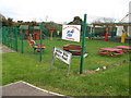
Play area in the Rascals 'N Ruffians Playgroup, Ballyholland
Image: © Eric Jones
Taken: 7 Nov 2016
0.16 miles
8
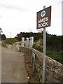
Mass Rock Lane
This lane off Bettys Hill Road leads to a rock where Mass was celebrated in Penal Times when Roman Catholics were not allowed to build churches. The OIRA memorial is located near the entrance to the lane. The following is a link to a photo of the Ballyholland Mass Stone.
http://www.dromorediocese.org/wp-content/uploads/2012/02/Mass-Rock-Ballyholland.jpg
Image: © Eric Jones
Taken: 7 Nov 2016
0.17 miles
9
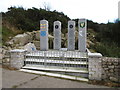
An OIRA memorial at Mass Hill, Ballyholland
This is a memorial for Volunteers Colman Rowntree and Martin McAlinden, members of the Official Irish Republican Army (OIRA), who were shot dead shortly after capture by the British Army while in the process of laying a landmine on the Bettys Hill Road outside Ballyholland, Newry.
Image: © Eric Jones
Taken: 7 Nov 2016
0.17 miles
10
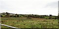
Inter-drumlin wetland alongside Billy's Road
It is feature of such areas that the settlements are sited on the drumlins.
Image: © Eric Jones
Taken: 7 Nov 2016
0.18 miles