IMAGES TAKEN NEAR TO
Temple Hill Road, NEWRY, BT34 2LS
Introduction
This page details the photographs taken nearby to Temple Hill Road, BT34 2LS by members of the Geograph project.
The Geograph project started in 2005 with the aim of publishing, organising and preserving representative images for every square kilometre of Great Britain, Ireland and the Isle of Man.

There are currently over 7.5m images from over14,400 individuals and you can help contribute to the project by visiting https://www.geograph.org.uk
Image Map
Images are licensed for reuse under creativecommons.org/licenses/by-sa/2.0
Notes
- Clicking on the map will re-center to the selected point.
- The higher the marker number, the further away the image location is from the centre of the postcode.
Image Listing (4 Images Found)
Images are licensed for reuse under creativecommons.org/licenses/by-sa/2.0
Image
Details
Distance
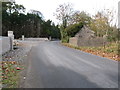
2
Temple Hill Road descending towards the junction with Fort Hill Road
Image: © Eric Jones
Taken: 7 Nov 2016
0.12 miles
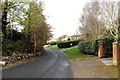
3
Junction of Fort Hill Road & Temple Hill Road
Image: © Neil Mitchell
Taken: 24 Jan 2010
0.14 miles
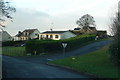
4
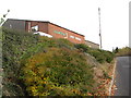
Nu-Mac Fabrications on Temple Hill Road
This factory is located in the eastern suburbs of Newry. It produces waste handling machinery such as compactors.
Image: © Eric Jones
Taken: 7 Nov 2016
0.24 miles