IMAGES TAKEN NEAR TO
Sandy Road, NEWRY, BT34 2LB
Introduction
This page details the photographs taken nearby to Sandy Road, BT34 2LB by members of the Geograph project.
The Geograph project started in 2005 with the aim of publishing, organising and preserving representative images for every square kilometre of Great Britain, Ireland and the Isle of Man.

There are currently over 7.5m images from over14,400 individuals and you can help contribute to the project by visiting https://www.geograph.org.uk
Image Map
Images are licensed for reuse under creativecommons.org/licenses/by-sa/2.0
Notes
- Clicking on the map will re-center to the selected point.
- The higher the marker number, the further away the image location is from the centre of the postcode.
Image Listing (4 Images Found)
Images are licensed for reuse under creativecommons.org/licenses/by-sa/2.0
Image
Details
Distance
1
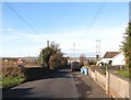
Approaching the Children's Playground on the Glenvale Road, Newry
The playground is the fenced off area on the left hand side of the road.
http://www.instantstreetview.com/@54.203288,-6.291713,279.17h,14.79p,1z
Image: © Eric Jones
Taken: 30 Nov 2016
0.16 miles
2
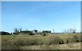
Wet land next to the A25
The drumlin beyond is much drier land suitable for both agriculture and settlement.
Image: © Eric Jones
Taken: 14 Mar 2017
0.19 miles
3
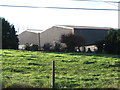
Poland Coach Works on Sandy Road, Glenvale
Poland is a surname of Gaelic origin which today is largely confined to Cos. Armagh and Down.
Image: © Eric Jones
Taken: 30 Nov 2016
0.20 miles
4
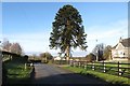
Araucaria araucana on Glenvale Road
This is a particularly fine example of a Monkey Puzzle tree.
Image: © Eric Jones
Taken: 30 Nov 2016
0.24 miles