IMAGES TAKEN NEAR TO
Newry Road, NEWRY, BT34 2JF
Introduction
This page details the photographs taken nearby to Newry Road, BT34 2JF by members of the Geograph project.
The Geograph project started in 2005 with the aim of publishing, organising and preserving representative images for every square kilometre of Great Britain, Ireland and the Isle of Man.

There are currently over 7.5m images from over14,400 individuals and you can help contribute to the project by visiting https://www.geograph.org.uk
Image Map
Images are licensed for reuse under creativecommons.org/licenses/by-sa/2.0
Notes
- Clicking on the map will re-center to the selected point.
- The higher the marker number, the further away the image location is from the centre of the postcode.
Image Listing (19 Images Found)
Images are licensed for reuse under creativecommons.org/licenses/by-sa/2.0
Image
Details
Distance

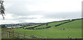
2
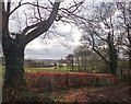
View over farmland in the direction of Derryleckagh Lake
Image: © Eric Jones
Taken: 13 Mar 2018
0.05 miles
3
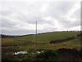
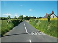
Powerlines north of Derryleckagh Lake
The image was taken from the B8 (Hilltown Road).
Image: © Eric Jones
Taken: 13 Mar 2018
0.06 miles
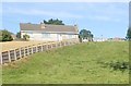
4
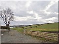
Farm road leading from the B8
The lake in the background is Derryleckagh Lake.
Image: © Eric Jones
Taken: 13 Mar 2018
0.12 miles
8
Drumlin at the northern end of Derrylackagh Lake
The image was taken from the B8.
Image: © Eric Jones
Taken: 16 Sep 2021
0.19 miles
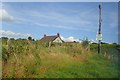
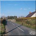
10
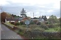
Cottage at the Aughnagone Road junction on the B8
Image: © Eric Jones
Taken: 29 Oct 2019
0.21 miles