IMAGES TAKEN NEAR TO
Drumlough Road, NEWRY, BT34 2HR
Introduction
This page details the photographs taken nearby to Drumlough Road, BT34 2HR by members of the Geograph project.
The Geograph project started in 2005 with the aim of publishing, organising and preserving representative images for every square kilometre of Great Britain, Ireland and the Isle of Man.

There are currently over 7.5m images from over14,400 individuals and you can help contribute to the project by visiting https://www.geograph.org.uk
Image Map
Images are licensed for reuse under creativecommons.org/licenses/by-sa/2.0
Notes
- Clicking on the map will re-center to the selected point.
- The higher the marker number, the further away the image location is from the centre of the postcode.
Image Listing (14 Images Found)
Images are licensed for reuse under creativecommons.org/licenses/by-sa/2.0
Image
Details
Distance
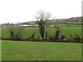
1
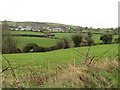
Rural settlement in the Townland of Drumgath
This image was taken from the Ballykeel Road.
Image: © Eric Jones
Taken: 14 Feb 2012
0.00 miles
2
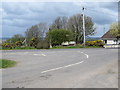
Junction of the Ballydoo Road and the B7 (Drumlough Road)
This junction is about 1.5 miles from Mayobridge and 4 miles from Rathfriland.
Image: © Eric Jones
Taken: 14 Apr 2012
0.02 miles
3
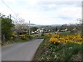
View north along the Drumlough Road (B7)
Linear settlement along this road linking Mayobridge and Rathfriland are a mixture of the old and the newly-built. Many of the older houses are now derelict.
Image
Image
Image: © Eric Jones
Taken: 14 Apr 2012
0.03 miles
4
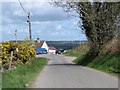
Ballydoo Road near its junction with the B7 (Drumlough Road)
The quarry entrance is on the right.
Image
Image: © Eric Jones
Taken: 14 Apr 2012
0.03 miles
5
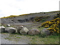
Quarry at the junction of Ballydoo and Drumlough roads
The rock here is friable and produces an ideal aggregate for track making.
Image: © Eric Jones
Taken: 14 Apr 2012
0.04 miles
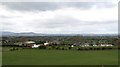
6
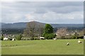
Pastureland between Ballydoo Road and the B7
The Cooley Mountains form the background.
Image: © Eric Jones
Taken: 14 Apr 2012
0.11 miles
7
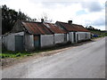
Traditional tin-roofed farmstead cottage alongside the Drumlough Road (B7)
This property is now disused.
Image: © Eric Jones
Taken: 14 Apr 2012
0.20 miles
8
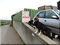
On the lookout for passing trade - two friendly dogs at a potato farm on the Ballydoo Road
Image: © Eric Jones
Taken: 14 Apr 2012
0.20 miles
9
Farmland and farm buildings east of the Ballykeel Road
Image: © Eric Jones
Taken: 14 Feb 2012
0.21 miles
10
Panorama westwards from Ballydoo Road
The buildings are on the Drumlough Road (B7). Beyond the view extends in the direction of South Armagh.
Image: © Eric Jones
Taken: 14 Apr 2012
0.22 miles