IMAGES TAKEN NEAR TO
Ballydoo Road, NEWRY, BT34 2HP
Introduction
This page details the photographs taken nearby to Ballydoo Road, BT34 2HP by members of the Geograph project.
The Geograph project started in 2005 with the aim of publishing, organising and preserving representative images for every square kilometre of Great Britain, Ireland and the Isle of Man.

There are currently over 7.5m images from over14,400 individuals and you can help contribute to the project by visiting https://www.geograph.org.uk
Image Map
Images are licensed for reuse under creativecommons.org/licenses/by-sa/2.0
Notes
- Clicking on the map will re-center to the selected point.
- The higher the marker number, the further away the image location is from the centre of the postcode.
Image Listing (3 Images Found)
Images are licensed for reuse under creativecommons.org/licenses/by-sa/2.0
Image
Details
Distance
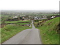
2
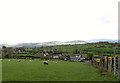
Modern housing on the Ballydoo Road
The last two decades have seen rural housing in Northern Ireland transformed. The majority of houses in the countryside are modern and many of the older houses are now derelict.
Image: © Eric Jones
Taken: 14 Apr 2012
0.19 miles
3
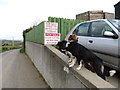
On the lookout for passing trade - two friendly dogs at a potato farm on the Ballydoo Road
Image: © Eric Jones
Taken: 14 Apr 2012
0.24 miles