IMAGES TAKEN NEAR TO
Carnany Road, NEWRY, BT34 2HF
Introduction
This page details the photographs taken nearby to Carnany Road, BT34 2HF by members of the Geograph project.
The Geograph project started in 2005 with the aim of publishing, organising and preserving representative images for every square kilometre of Great Britain, Ireland and the Isle of Man.

There are currently over 7.5m images from over14,400 individuals and you can help contribute to the project by visiting https://www.geograph.org.uk
Image Map
Images are licensed for reuse under creativecommons.org/licenses/by-sa/2.0
Notes
- Clicking on the map will re-center to the selected point.
- The higher the marker number, the further away the image location is from the centre of the postcode.
Image Listing (4 Images Found)
Images are licensed for reuse under creativecommons.org/licenses/by-sa/2.0
Image
Details
Distance
1
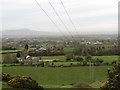
Power lines descending into the valley
This view was taken from Carnany Road.
Image: © Eric Jones
Taken: 14 Feb 2012
0.04 miles
4
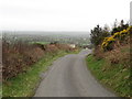
The B7 Drumlough Road west of the Carnany Cross Roads
This is a narrow but busy road.
Image: © Eric Jones
Taken: 14 Feb 2012
0.24 miles