IMAGES TAKEN NEAR TO
Bavan Heights, NEWRY, BT34 2GU
Introduction
This page details the photographs taken nearby to Bavan Heights, BT34 2GU by members of the Geograph project.
The Geograph project started in 2005 with the aim of publishing, organising and preserving representative images for every square kilometre of Great Britain, Ireland and the Isle of Man.

There are currently over 7.5m images from over14,400 individuals and you can help contribute to the project by visiting https://www.geograph.org.uk
Image Map
Images are licensed for reuse under creativecommons.org/licenses/by-sa/2.0
Notes
- Clicking on the map will re-center to the selected point.
- The higher the marker number, the further away the image location is from the centre of the postcode.
Image Listing (39 Images Found)
Images are licensed for reuse under creativecommons.org/licenses/by-sa/2.0
Image
Details
Distance
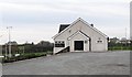
1
Mayobridge Youth and Community Centre, Old Road, Mayobridge
Image: © Eric Jones
Taken: 14 Feb 2012
0.05 miles
2
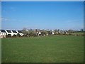
Farmland on the eastern outskirts of Mayobridge
Image: © Eric Jones
Taken: 2 Mar 2011
0.06 miles
3
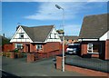
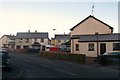
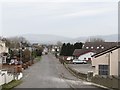
Houses on the eastern outskirts of Mayobridge
Image: © Eric Jones
Taken: 25 Sep 2017
0.07 miles
5
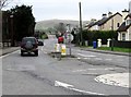
Hilltown Road on the eastern outskirts of Mayobridge
Image: © Eric Jones
Taken: 14 Feb 2012
0.08 miles
6
View westwards along Old Road, Mayobridge
The building with the roof lights is the Youth and Community Centre.
Image: © Eric Jones
Taken: 14 Feb 2012
0.08 miles
7
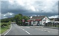
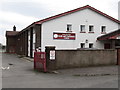
Spar store at the eastern outskirts of Mayobridge
Image: © Eric Jones
Taken: 30 Jun 2011
0.08 miles
8
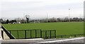
The Clubhouse of the Mayobridge GAA Club
Image: © Eric Jones
Taken: 14 Feb 2012
0.08 miles
9

Vivo Store at Mayobridge
This village store is located on the B8 (Hilltown Road).
Image: © Eric Jones
Taken: 9 Jun 2021
0.09 miles