IMAGES TAKEN NEAR TO
Mill Lane, NEWRY, BT34 2ER
Introduction
This page details the photographs taken nearby to Mill Lane, BT34 2ER by members of the Geograph project.
The Geograph project started in 2005 with the aim of publishing, organising and preserving representative images for every square kilometre of Great Britain, Ireland and the Isle of Man.

There are currently over 7.5m images from over14,400 individuals and you can help contribute to the project by visiting https://www.geograph.org.uk
Image Map
Images are licensed for reuse under creativecommons.org/licenses/by-sa/2.0
Notes
- Clicking on the map will re-center to the selected point.
- The higher the marker number, the further away the image location is from the centre of the postcode.
Image Listing (57 Images Found)
Images are licensed for reuse under creativecommons.org/licenses/by-sa/2.0
Image
Details
Distance
1
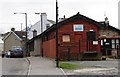
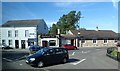
Blue Dragon Chinese Restaurant, Mayobridge
Image: © Eric Jones
Taken: 14 Feb 2012
0.04 miles
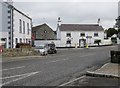
2
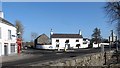
The junction of the B8 (Hilltown Road) and the northern section of the B7 (Bevan Road) at Mayobridge
This is the original core of the village.
Image: © Eric Jones
Taken: 19 Feb 2013
0.05 miles
3
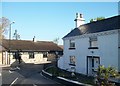
The entrance into Bavan Road (B7) from Hilltown Road (B8)
Image: © Eric Jones
Taken: 14 May 2010
0.06 miles
4
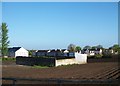
Arable land in the centre of Mayobridge
The land around it has been developed, but this large field, which also has what appears to be a pig-sty, is still being intensively farmed. The housing estate is on the other side of the B7.
Image: © Eric Jones
Taken: 14 May 2010
0.06 miles
5
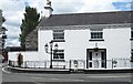
House at the corner of the Newry and Bavan roads at Mayobridge
Image: © Eric Jones
Taken: 30 Jun 2011
0.06 miles
6
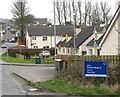
Modern housing off the Bavan Road at the northern approach into Mayobridge
In Gaelic, Mayobridge is known as Droiched Mhaigh Eo. This means "bridge on the plain of the yews".
Image: © Eric Jones
Taken: 14 Feb 2012
0.06 miles
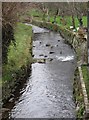
7
Ballyvally Road, Mayobridge
The first stretch of the Clanrye River flows alongside the road.
Image: © Eric Jones
Taken: 20 Feb 2010
0.07 miles
8
The canalised Clanrye River north of the B8 at Mayobridge
Image: © Eric Jones
Taken: 14 Feb 2012
0.07 miles
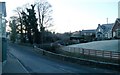
10
The crossroads at the centre of the village of Mayobridge
Here the B8 Newry to Hilltown Road is intersected by the B7 Bavan Road and the Ballyvally Road.
Image: © Eric Jones
Taken: 14 Sep 2011
0.07 miles