IMAGES TAKEN NEAR TO
Bavan Road, NEWRY, BT34 2EP
Introduction
This page details the photographs taken nearby to Bavan Road, BT34 2EP by members of the Geograph project.
The Geograph project started in 2005 with the aim of publishing, organising and preserving representative images for every square kilometre of Great Britain, Ireland and the Isle of Man.

There are currently over 7.5m images from over14,400 individuals and you can help contribute to the project by visiting https://www.geograph.org.uk
Image Map
Images are licensed for reuse under creativecommons.org/licenses/by-sa/2.0
Notes
- Clicking on the map will re-center to the selected point.
- The higher the marker number, the further away the image location is from the centre of the postcode.
Image Listing (6 Images Found)
Images are licensed for reuse under creativecommons.org/licenses/by-sa/2.0
Image
Details
Distance
2
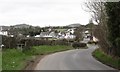
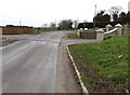
Entering the Maybridge 30mph zone on Bavan Road
Image: © Eric Jones
Taken: 14 Feb 2012
0.16 miles
3
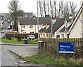
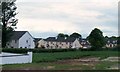
Modern housing off the Bavan Road at the northern approach into Mayobridge
In Gaelic, Mayobridge is known as Droiched Mhaigh Eo. This means "bridge on the plain of the yews".
Image: © Eric Jones
Taken: 14 Feb 2012
0.18 miles